This item has been sold, but you can enter your email address to be notified if another example becomes available.


|
||

|

|
|

|
Stock# 61197
Description
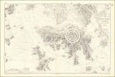
An American Hong Kong Rarity
Rare First State of the US Naval Hydrographical Survey Chart of Hong Kong and vicinity, published in Washington, D.C. in 1886.
Detailed chart of the approaches to Hong Kong, with the lighthouses touched with color.
Despite being a sea chart the streets of the settlements are carefully delineated.
This chart was published as the U.S. was working to increase its sphere of influence across the Pacific.
Rarity
OCLC locates only a single example of a later 1889 edition of the map (Boston Public Library).
Condition Description
Cleaned and backed. Several repaired tears and evidence of vertical splitting in two places, crossing the entire map vertically.
![[Victoria] Hong Kong Island](https://storage.googleapis.com/raremaps/img/small/82303.jpg)
![[Ladrone Islands / Wanshan Archipelago] Ladronen Chine](https://storage.googleapis.com/raremaps/img/small/90221.jpg)
![[ Hong Kong / Canton ] Nieuwe Pas=Caart Strekkende van Pta Cataon tot Pta Lamtaon langs de kusten von Cochinchina, Tonquin, Quangsi en Quantung bewattende insgelyks het eiland Aynam en die van Macao met dieptens, havens en ankergronden . . .](https://storage.googleapis.com/raremaps/img/small/66695.jpg)