|
||

|

|
|

|
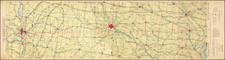
Select Your Home in Iowa
Rare separately published broadside map of a portion of Western Iowa, promoting the lands of the Iowa Railroad Land Company.
“A Choice from 700,000 acres of rich rolling prairie, and valley land, in farms to suit, Free from Mortgage or Other Incumbrances.”
The map covers a large portion of west central Iowa, showing from Harrison to Sioux Counties along the Missouri River, to Clay County in the northeast and Carroll County in the southeast. All or part of 13 counties are shown.
At the bottom is a large inset showing, utilizing the only color to illustrate the location of the lands with respect to Iowa and northern Illinois.
Two paragraphs of promotional text at bottom right extols the desirability of the lands. Grey shading indicates land available for sale.
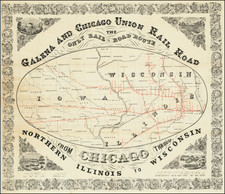
Iowa Railroad Land Company
The Iowa Railroad Land Company was organized in 1869 by the stockholders. of the Cedar Rapids and Missouri River Railroad. The land grant of that railroad company was conveyed to the Iowa Railroad Land Company September 15, 1869, to continue development of lands originally acquired under the Iowa Land Act of 1856, which was passed by Congress to encourage the construction of 4 Iowa railroad lines. In 1887 the Iowa Railroad Land Company bought from the Iowa Falls and Sioux City Railroad Company its unsold lands.
The printer Henry S. Stebbins' address at 264 Wabash suggests a date before 1881, when Stebbins began operating from 262 & 264 Wabash Avenue, in Chicago.
Rarity
The map is unrecorded. Not in Printed Maps of the Midwest, Volume 8.
![[Montana, Wyoming, Colorado, Dakotas, etc] Reconnaissances in the Dacota Country By G.K. Warren](https://storage.googleapis.com/raremaps/img/small/82655.jpg)