


|
||

|

|
|

|
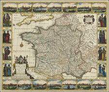
Carte-a-Figures Antique Map of France
An extremely decorative map of France published by one of the best 17th-century Dutch mapmakers. The map itself is attractively designed, neatly laid out, and well-presented, but what makes this engraving stand out are the vignettes that surround the map.
Twelve city views are shown above and below the map. These show many important French urban centers at a time during which they were growing rapidly. Many are still constrained by their old city walls, although some have started to expand outwards. The cities shown include Paris, Orleans, Poitiers, Rouen, La Rochelle, Bordeaux, Calais, Beaumont, Angiers, Bourges, Lyon, and Tours.
The sides of the map display various traditional costumes present in France at the time. This shows the extremely class-segregated society, where individual positions and jobs have their own ways of dressing. At the top of both sides are shown French noblemen and noblewomen, dressed in exquisite clothing. Below them are merchants, dressed slightly less ornately, and French peasants, dressed in colorful traditional clothes. French lawyers and their wives are shown at the base of the map. The corners of the map show portraits of the king and queen of France at the time, Louis XIII and his wife, Anna Maria.
Despite the draw of the decorative images, the map itself should not be neglected. Visscher's work is remarkably detailed, with many cities, towns, and rivers shown. Detail extends into neighboring Spain, Piedmont, Belgium, Luxembourg, and England. In all, a very decorative map.
![[La Rochelle] Rochella Munitissimum Galliae Opp.](https://storage.googleapis.com/raremaps/img/small/77250.jpg)
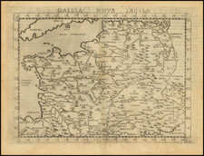
![[France]. Das Gantz Franckreich so voz zeiten Gallia Narbonensis, Lugaunensis, Belgica und Celtica. . .](https://storage.googleapis.com/raremaps/img/small/83119.jpg)
![[ France and Low Countries ] Totius galliae descriptio, cum parte Angliae, Germaniae, Flandriae, Brabantiae, Italiae, Romam usque](https://storage.googleapis.com/raremaps/img/small/74214.jpg)