|
||

|

|
|

|
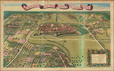
Antique Map / City Plan of Florence
Fine early plan of Florence, engraved by Wenceslaus Hollar.
A the top right is the Medici coat of arms with balls, while on the left, within a cartouche, a legend with 17 entries within the Fortezza da Basso and at the bottom right is the main legend with 228 entries in three columns.
On either side of the plan of Florence are 10 views, including
- the monument of Cosimo I on horseback
- the Duomo with the bell tower
- side access roads to Piazza dell'Annunziat
- seven Florentine street views showing various games and sports
The image is very similar to the prototype; in addition to the presence of the Belvedere Fortress and the absence of the monument to Cosimo I in Piazza S. Marco, small variations can be seen in the drawing of Via S. Gallo, in the area of Borgo Pinti, Via de Serragli and the square before the ducal palace. As in the Bonsignori view, the major religious centers stand out with the annexed squares, S. Maria Novella, S. Lorenzo, S. Marco, the Annunziata, S. Croce, the Ognissanti, and beyond the Carmine and S. Spirito; the axonometric view of the Duomo is enlarged and altered to allow better use; other prominent elements are the ducal seat, Palazzo Pitti, and Palazzo Vecchio. All the important buildings are defined with care and precision, but the changes made in the urban fabric since 1584 are not taken into consideration. The prototype is also taken up in the design of the area outside the walls, to bring back in some cases the same layout of rows of trees and the same differentiation of cultivated fields; however, a certain impoverishment can be noted from a graphic point of view, in particular for the simplification and normalization of tree species.
Hollar's view was reissued in Amsterdam in the 1700s by De Wit and the same image is also found in the Historia fiorentina di Giovanni Michele Bruto e nel Thesaurus antiquitatum et historiarum Italiae di Giovanni Giorgio Grevio, published in Leiden in 1723.
In 1663 another view is published derived from the prototype of Bonsignori through the interpretation of the Hollar, contained in the Theatrum civitatum by Jan Blaeu; in 1704 it was re-edited by Pierre Mortier, inside the Nouveau Theater d'Italie, in Amsterdam, entitled La ville de Florence, The title and cartouche are placed in different parts of the map.
While the De Wit edition of the map appears occasionally on the market, this edition, without text below the side panels, is apparently quite scarce.
![[Loreto]. Lauretum](https://storage.googleapis.com/raremaps/img/small/77536.jpg)
![[Ostia, the Harbor of Rome] Claudii Et Traiani Impp Admirabilium Portuum Ostiensium Orthographia Per Stephanum Du Perach Architectum Iuxta Antiqua Vestigia Accuratissime Delineata . . . 1581](https://storage.googleapis.com/raremaps/img/small/75639.jpg)
![[Fossano] Delinea Civitatis Fossani In Principatu Pedemontii](https://storage.googleapis.com/raremaps/img/small/59445.jpg)