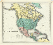
![[ Sea of the West ] L'Amerique Septentrionale divisee en ses principaux Etats . . . 1782 By Jean Janvier](https://storage.googleapis.com/raremaps/img/small/80228.jpg)


|
||

|

|
|

|
Antique Map of North America – Showing Mythical Bay of the West!
Fine example of the last edition of Janvier's map of North America to illustrate the intriguing Sea of the West, prior to the incorporation of information from Cook's final voyage.
In this late edition, the earlier plate has been changed to delete the words “du Roy” from the publication privilege.
The interior of North America is split into the United States, Canada, Louisiana, and Spanish holdings. The western reaches are peppered with numerous Indigenous names and early French forts. Iceland is marked as a possession of Denmark.
Greenland appears connected to the continent north of Baffin Bay. Also far north, but to the west, the Alaskan peninsula is tentatively theorized based on reports of Vitus Behring’s crews (here “Beering”) on their First and Second Kamchatka Expeditions (1728-30, 1733-43), as well as more recent Russian expeditions.
Sea of the West
Whereas the inclusion of the United States is up to date, other inclusions on the map were less common by the 1770s. The feature that most attracts the attention of the modern viewer is the Mer ou Baye de l’Ouest in the interior of North America. The Sea of the West, which had first appeared on charts published by Johann Baptiste Nolin in ca. 1700, had quickly disappeared thereafter. However, in 1752, Philippe Buache and Joseph Nicholas De L’Isle, Guillaume’s son-in-law and brother respectively, included the sea on their controversial map highlighting the recent discoveries by the Russians in the far northern Pacific. While a few other mapmakers adopted and modified the feature, it was not common on maps of the 1770s and 1780s.
The re-introduction of the sea was the result of Buache’s review of his father-in-law’s papers. Although Guillaume De L’Isle never published a map showing the sea, he had postulated that it could exist, and that it might connect to a Northwest Passage through New France, not through English territory farther north. Nolin had plagiarized the idea from Guillaume, as the latter testified when suing the former for plagiarism. He said, the Sea of the West “was one of my discoveries. But since it is not always appropriate to publish what one knows or what one thinks one knows, I have not had this sea engraved on the works that I made public, not wanting foreigners to profit from this discovery” (as quoted in Pedley, 109).
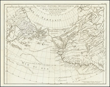
The Russian discoveries in the Pacific Northwest and the odd case of Statchan Nitada
The sea between North America and Russia is now filled with islands and labels. These originate from, as the map states, “Découvertes par les Russes depuis 1740,” or discoveries made by the Russian by 1740.
Two expeditions led by Vitus Behring (1728-30, 1733-43) explored Kamchatka and what is now Alaska, charting the strait between them. The first maps of the discoveries appeared in France in the early 1750s, followed by a German map by Gerhard Müller, a member of the second Kamchatka Expedition, first published in 1754 and distributed more widely in a 1758 edition. These maps, though they differed in many respects, show the strait between the continents and the westward thrust of the Alaskan mainland/archipelago.
In the 1760s, Russian fur traders discovered more and more of the Aleutian Islands, some of which are shown here. In 1764, another Second Kamchatka Expedition veteran, Lieutenant Ivan Synd, led a new voyage to the Bering Sea. He was in search of the Northwest Passage, but also hoped to clarify to what extent western Alaska was a peninsula or an archipelago. He produced several maps, all but one of which have been lost. The map that does survive shows a series of islands nearly touching Kamchatka, not a peninsula.
As a result of Synd’s findings, a modified 1773 Russian edition of Müller’s chart converts Müller’s large peninsula to a string of islands. In the same year Jacob von Stählin, secretary to the Russian Academy of Sciences, created his own map based on Synd’s discoveries entitled, “A Map of the New Northern Archipelago discover’d by the Russians.” This map, published in a book with a similar title, was a source for this 1774 edition of Covens & Mortier’s map of the Americas. Although it does not copy Stählin’s map exactly—it does not include a large Alaschka Island, for example—the Covens & Mortier map does adopt several toponyms from the Stählin map, including Stachtan Nitada on the North American mainland, near the Arctic Circle.
Written as Satchan Nitada on the Covens & Mortier example, this toponym seems to have been included for the first time by Stählin. It is supposedly a place Synd landed at and is near the sighting of the Alaskan mainland by the Russians in 1730, an event also marked on this map. The book excited members of the Royal Society of London, who ensured that the German language publication was translated into English by the end of 1774.
However, Stachtan Nitada’s precise location and importance remained unclear to explorers, none more so than James Cook. Cook carried the English translation of Stählin’s map with him on this third voyage, which was focused on finding the Northwest Passage. What interested Cook was the strait between Stachtan Nitada and the nearest island to the west, a feature repeated, in reduced form, on this map. It seemed to Cook and others planning his third voyage that this could be an entrance to a Northwest Passage.
When Cook arrived in search of the islands and passage in 1778, he found no such place. As J.C. Beaglehole, Cook’s twentieth-century editor, explains:
…no one could be too hard on Stählin. He had thrown the name Alaska on to an arbitrary island in the north; the other name Stachtan Nitada was unknown to either Russian or Aleut…As a cartographer he was naïve, even infantile; and he was unwise enough to speak slightingly of seamen. (Journals of Captain Cook, cxxxvii-cxxxviii)
Cook himself had choice words about Stählin and Stachtan Nitada. In his journal of October 1778, he wrote:
Stachtan Nitada as it is calld in the Modern maps, is a name quite unknown to these people, Indians as well as Russians, but both know it by the name of America. (251)
Of Stählin’s map, Cook wrote later in October 1778:
If Mr Stehlin was not greatly imposed upon what could induce him to publish so erroneous a Map? in which many of these islands are jumbled in in [sic] regular confusion, without the least regard to truth and yet he is pleased to call it a very accurate little Map? A Map that the most illiterate Seafaring men would have been ashamed to put his name to. (456)
Cook would not test Stählin’s hypotheses until late in the 1770s, and this state of the map does not incorporate the information from his third voyage (1776-1780). For that reason, Stachtan Nitada appears here and on several other contemporary maps and is an enduring example of the conjectural nature of mapmaking.
![[ New France - Pierre Biard's Letter ] Missio Canadensis [in] Annuæ Litteræ Societatis Jesu Anni MDC.XI.](https://storage.googleapis.com/raremaps/img/small/84352.jpg)