|
||

|

|
|

|
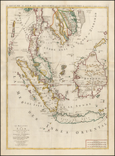
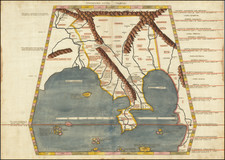
Exceedingly Rare Horsburgh Chart of Singapore and Adjacent Islands in the Strait of Singapore
Very rare second state of Horsburgh's important chart of the Singapore Strait, first published in 1821.
The present example may be the earliest extent surviving example of the chart, as no examples are known in institutional collections. This 1824 example is extremely rare, with only two examples recorded institutional collections.
This is one of the earliest charts to show the Strait after the British had established themselves on the island of Singapore in 1819.
The chart shows the varying state of geographic knowledge about these important waterways just as Singapore was becoming one of Britain’s most important colonial assets. “Singapoora Town” is marked with a square symbol, the only settlement to be so acknowledged. The soundings in and around Singapore are laid so thickly that there is hardly any free space. However, the island of Singapore itself has its western end sliced off and is split into two, Goa Island and Tooly Island.
Farther away from Singapore, however, the remaining absences in geographic knowledge are readily apparent. Many shores and straits are labeled as “imperfectly known,”, while several courses are marked as, “probably a safe channel.”
Where information is known, Horsburgh is careful to site his sources. For example, he mentions the HMS Buffalo, which “passed amongst the Islands to the Eastward of Dryon” in October 1803. The Buffalo, a storeship, had previously delivered cattle to New South Wales and two black swans and three emus to England. After returning to Australia, Buffalo sailed to Bengal via the waters shown here, arriving in June 1804.
Also mentioned is the Nonsuch, in a voyage of 1783. The first ship of its size ever constructed at Calcutta, the Nonsuch was a merchant vessel launched in 1781. However, it was also built to act as a man-of-war, with a full armament and sailors trained as marines. The ship was used as part of the illicit opium trade with China; its is one these opium voyages chronicled in this chart.
In the remarks in the upper left corner, Horsburgh states his use of the surveys of a Captain Ross. This is Captain Daniel Ross. Ross was a famous surveyor for the East India Company. Born in Jamaica, Ross joined the Bombay Marine and eventually was appointed Marine Surveyor General. He made many surveys of Southeast Asia and the coasts of China throughout the 1810s and 1820s, a service for which he was elected a Fellow of the Royal Society.
Two other sources are identified in the title/dedication in the upper left corner. Horsburgh mentions James Carnegy and Robert Scott, both of Prince of Wales Island. These men were employees of the EIC or, “commanders in the Malay Trade,” as Horsburgh puts it. While there are Prince of Wales Islands in Canada, Alaska, and Australia, this mention refers to Penang Island, Malaysia, in the Malacca Strait. Originally called Prince of Wales Island, its principal city, George Town, was founded in 1786 by the EIC. When this chart was published, George Town was one of the principal British settlement in the region; it was the capital of the Straits Settlements until it was eclipsed by Singapore in 1836.
The chart appears to exhibit many of the precise lines and crisp, yet sparing, details that would come to characterize the charts published by the British Admiralty’s Hydrographic Office (HO). The HO had been publishing their own charts since 1800, when they acquired a printing press, but for certain areas of the world they were still dependent on other sources, such as the EIC’s Horsburgh. The Admiralty started selling charts to the public in 1822. They later bought and re-published many of Horsburgh’s charts.
The chart also includes views of landmarks like hills and plateaus as they would be seen from the sea. These are stylistically reminiscent of charts in eighteenth-century voyage accounts. This mixture of modern detail and blank spaces with older styles of showing views mark this chart as a transitional document exhibiting the changing cartographic styles common to the early-nineteenth century.
Britain and Singapore in the early-nineteenth century
The Straits of Singapore and Malacca have always been strategically valuable to trading powers. Initially, local and Asian powers fought for control of the waters. By the seventeenth century, several Europeans empires, and particularly the Dutch, were also sailing, trading, and living in the Straits. By the early-nineteenth century, Britain, the primary imperial super power after the defeat of Napoleonic France, sought to establish a powerful and important base in the waterway.
In the beginning of the nineteenth century, Singapore was controlled, at least nominally, by the Sultanate of Johor. The Sultan, in turn, answered to Dutch trading interests and the Bugis. The British, determined to challenge the primacy of the Dutch in the islands of southeast Asia, were looking to establish a port in or near the Straits of Malacca, the pipeline between China and British India.
Sir Stamford Raffles, Lieutenant Governor of the British colony at Bencoolen and employee of the British East India Company (EIC), recognized the strategic value of the island of Singapore, as well as its potential as a port. Lord Hastings, Governor-General of India, approved of an expedition and Raffles landed in Singapore in late January 1819. Raffles manipulated local politics and struck a deal to financially back his preferred leader in return for a trading post on the island. He signed a treaty on February 6, 1819 approving the British free port and marking the beginning of an official British presence in Singapore.
The first edition of this chart, printed in 1821, was therefore one of the first to show the town and Strait after it became a British possession. In 1824, when the present second edition of the chart was published, the Sultan ceded the island to the EIC in perpetuity. Horsbrugh was then the Hydrographer to the EIC.
When Raffles landed, there were roughly 1,000 people living on the island. By 1871, there were 100,000. Thanks to its status as a free port, Singapore quickly became a prime stopping point for explorers, traders, and officials. These included now famous explorers, like Hyacinthe de Boungainville, Auguste Nicholas Vaillant, and Dumont D’Urville. By the 1840s, a new harbour became necessary to handle the volume of shipping that was crowding the island. This chart, in updated editions, was used throughout this formative period in Singapore’s history.
Rarity
The chart would be periodically updated and revised until at least 1850. We note editions of 1821, 1824, 1831, 1841, 1849, 1850. While some of these later editions (post 1840) of the significantly-updated chart appear occasionally on the market, this early state is very rare.
OCLC locates no copies of the 1821 edition and only two copies of the 1824 edition (National Library of Singapore and British Library).
This is an important document which shows changing cartographic techniques. It is linked to several of the most important hydrographers of Southeast Asian waters, including Daniel Ross and James Horsburgh. It is also one of the earliest charts made of the Strait after the British take-over of Singapore. For all these reasons, it deserves a prominent place in any collection of EIC, Singaporean, or Southeast Asian hydrography.
James Horsburgh (1762 -1836) was a Scottish hydrographer who worked for the British East India Company (EIC) and charted much of China, Southeast Asia, India and contiguous regions in the late eighteenth and early nineteenth centuries.
Horsburgh went to sea at the age of sixteen and was captured and imprisoned by the French at Dunkirk. After his release, he made voyages to the West Indies and Calcutta. In 1786, as first mate in the Atlas, Horsburgh sailed from Batavia to Ceylon and was subsequently shipwrecked on the island of Diego Garcia. This disaster influenced him in his decision to produce accurate maps after he found his way back to India.
EIC hydrographer Alexander Dalrymple published three of Horsburgh’s earliest charts of the Straits of Macassar, of the western Philippines, and of the tract from Dampier's Strait to Batavia. In 1799, Dalrymple published Horsburgh’s Observations on the Eastern Seas on behalf of the EIC.
Meanwhile, Horsburgh continued his sailing career in the Carron, which had been taken up by the British government as a transport to the West Indies and, on his return to England, sailed again for Bombay. There, in April 1798, he was appointed to the command of his old ship, the Anna, and during the next seven years he made two voyages to England, besides several to China, Bengal, and Madras.
On the return trips to England in 1799 and 1801, Horsburgh became acquainted with the London scientific community including Sir Joseph Banks, the astronomer Nevil Maskelyne, and Henry Cavendish. Horsburgh kept barometric records for Cavendish during his voyages from 1802 to 1804, which elucidated the diurnal variation in the open sea between 26°N and 26°S. It was these measurements and his high society contacts that assured Horsburgh nomination and approval as a Fellow of the Royal Society upon his retirement from the sea in 1806.
Horsburgh continued to publish on nautical navigation. In 1806, he released Memoirs Comprising the Navigation to and from China. Next, in 1809 and 1811, Horsburgh finalized Directions for Sailing to and from the East Indies, China, New Holland, Cape of Good Hope, and the interjacent Ports, compiled chiefly from original Journals and Observations made during 21 years' experience in navigating those Seas, also known as the India Directory. These publications made Horsburgh a likely candidate for the position of hydrographer to the EIC, a post he gained in 1810. While serving as hydrographer he revised the Directory, with subsequent editions in 1816-7, 1826-7, and 1836. He also oversaw the compilation and publication of the EIC’s Atlas of India in 1827.
Horsburgh died in 1836. However, his legacy lived on. Friends and admirers in Canton raised a memorial subscription and erected the Horsburgh Lighthouse on Pedro Branca in the Strait of Singapore. With the permission of his children, the Admiralty took up the Directory and released editions in 1841, 1852, 1855, and 1864. After his death and with the demise of the EIC, his charts passed to the Admiralty Hydrographic Office, who reissued them.