|
||

|

|
|

|
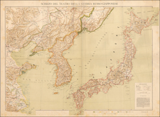
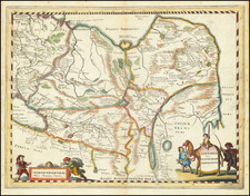
One of the First Charts to Use The Modern Name for Hong Kong
Extremely rare sea chart of Hong Kong by Aaron Arrowsmith, published in London 1812, the second earliest map to properly name "Hong Kong."
The chart covers the largely incomplete coastline of Hong Kong and the surrounding regions, with a large inset of Macau and a second inset map extending further east from Hailing Island to Boho Harbor and Dafangii Island.
Source Material: Daniel Ross and John Barrow
The chart is based on three contemporary charts: Daniel Ross’ 1810 Chart of the different Passages leading to Macao Roads, the first map to use the modern name Hong Kong, and Ross' 1807 This Survey of part of the South Coast of China. Arrowsmith merged the information from Ross' two charts around Macao. Interestingly, Arrowsmith ignores the more advanced cartography around Macao from Ross' Macao Roads in favor of the outlines of the South Coast of China. This raises the possibility that Arrowsmith was taking his map directly from a single Daniel Ross manuscript map.
While earlier charts had begun to reference "Hyong Kong" or "Heong Kong" in the late 18th century, it was not until Ross's remarkable chart of 1810 that the name was corrected to its modern usage.
As Ross was not allowed into Macao, and could not prosecute a survey of the area, the inset of Macao is based on John Barrow's 1796 A plan of the city and harbour of Macao a colony of the Portugueze situated at the southern extremity of the Chinese Empire, which appeared in Staunton's Embassy.
There were two primary mapping traditions at the time this map was made: the tradition stemming from Huddart (Laurie & Whittle; Steel; etc.) and from Ross (Ross; Ross manuscript tradition; Arrowsmith). Norie issued a chart that combined the traditions (relying heavily on Ross). Ross was a substantial improvement over Huddart.
Rarity
Arrowsmith's chart is an exceptional rarity, for which we locate only a single example in the British Library (OCLC 556903061).
No copy located at auction or in dealer catalogs.
The Arrowsmiths were a cartographic dynasty which operated from the late-eighteenth century to the mid-nineteenth. The family business was founded by Aaron Arrowsmith (1750-1823), who was renowned for carefully prepared and meticulously updated maps, globes, and charts. He created many maps that covered multiple sheets and which were massive in total size. His spare yet exacting style was recognized around the world and mapmakers from other countries, especially the young country of the United States, sought his maps and charts as exemplars for their own work.
Aaron Arrowsmith was born in County Durham in 1750. He came to London for work around 1770, where he found employment as a surveyor for the city’s mapmakers. By 1790, he had set up his own shop which specialized in general charts. Arrowsmith had five premises in his career, most of which were located on or near Soho Square, a neighborhood the led him to rub shoulders with the likes of Joseph Banks, the naturalist, and Matthew Flinders, the hydrographer.
Through his business ties and employment at the Hydrographic Office, Arrowsmith made other important relationships with Alexander Dalrymple, the Hudson’s Bay Company, and others entities. In 1810 he became Hydrographer to the Prince of Wales and, in 1820, Hydrographer to the King.
Aaron Arrowsmith died in 1823, whereby the business and title of Hydrographer to the King passed to his sons, Aaron and Samuel, and, later, his nephew, John. Aaron Jr. (1802-1854) was a founder member of the Royal Geographical Society (RGS) and left the family business in 1832; instead, he enrolled at Oxford to study to become a minister. Samuel (1805-1839) joined Aaron as a partner in the business and they traded together until Aaron left for the ministry. Samuel died at age 34 in 1839; his brother presided over his funeral. The remaining stock and copper plates were bought at auction by John Arrowsmith, their cousin.
John (1790-1873) operated his own independent business after his uncle, Aaron Arrowsmith Sr., died. After 1839, John moved into the Soho premises of his uncle and cousins. John enjoyed considerable recognition in the geography and exploration community. Like Aaron Jr., John was a founder member of the RGS and would serve as its unofficial cartographer for 43 years. Several geographical features in Australia and Canada are named after him. He carried the title Hydrographer to Queen Victoria. He died in 1873 and the majority of his stock was eventually bought by Edward Stanford, who co-founded Stanford’s map shop, which is still open in Covent Garden, London today.
![[Heightened with Gold!] Paskaerte Zynde t'Oosterdeel Van Oost Indien, met alle de Eylanden daer ontrendt geleegen van C. Comorin tota aen Iapan](https://storage.googleapis.com/raremaps/img/small/83769.jpg)