|
||

|

|
|

|
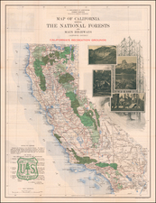
"What Is Wanted Is To Tell As Many Prospective Visitors As Possible All They Would Want To Know About A Trip Into The Mountains'
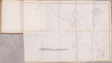
Rare early map promoting tourism in California's National Forests, likely produced with the encouragement of Coert Duboise, District Five Forester.
The map provides a fine overview of all of California's National Forests, with photographic images and an admonition of the six rules for preventing forest fires, apparently already a significant problem with recreational users. Some of the rules include:
- 2. Tobacco. Throw pipe ashes and cigar or cigarette stumps in the dust of the road, and stamp or pinch out the fire before leaving them. Don't throw them in the brush, leaves, or needles.
- 6. Fires. If you find a fire, try to put it out. If you can't get word of it to the nearest U.S. Forest Ranger or State Fire Warden at once . . .
The verso contains an illustrated guide for how to use "California's Recreational Grounds."
This would seem to be the earliest promotional map and tourist guide for use of the National Forests in California, developed at the behest of one of the senior Forestry officers in the region. The following is a short essay by Coert Duboise is excerpted from the John Muir Memorial Number of the Sierra Club Bulletin for January 1916 (p 117-120):
Development of the Recreation Use of the National Forests -- A Circular Letter to Forest Officers
* * *
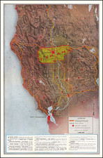
What is wanted is to tell as many prospective visitors as possible all they would want to know about a trip into the mountains. A map is probably the most effective and useful means of conveying this information. Suppose each Forest starts systematically to work this winter preparing the very best "Recreation Map" possible. The information is all collected—it is either in the files or in the heads of one or more officers. It remains only to get it into usable shape.
Take the camper map as a base, and put all the recreation data on it as shown in the attached legend. I am informed that it will be mechanically impossible to run our existing camper maps through the press and have this data printed on them. Therefore, each Forest will go ahead and prepare the rough draft for a new edition of recreation maps which we will request Washington to lithograph for us in large numbers. These maps when completed should show to the prospective visitor everything of interest or value, among which are:
1. Outfitting points:
Where camp supplies can be obtained.
Where gasoline can be obtained.
Where saddles and pack stock can be obtained.
Where guides, packers or camp-tenders can be obtained.
Ranches where butter, milk, eggs, etc., can be obtained.
Where meals and lodging can be obtained.
2. Routes of travel:
Roads passable for autos.
Roads passable for wagons.
Trails passable for stock.
Trails passable for foot travel.3. Horse-feed:
Meadows where cattle-grazing is permitted.
Meadows where cattle-grazing is not permitted.
Meadows fenced for use of traveling public.
Meadows fenced for use of Forest officers only.4. Particularly good camp grounds.
5. Interesting areas and scenic points:
Forest.
Particularly fine timber.
Forest Service stations or improvements.
Telephones, post-offices, stage stations, etc.
Of geological or historical interest.
Of botanical interest.Of interest to mountain climbers (safest routes to top indi-
cated).
Of interest to hunters.Localities where deer, bear, quail, grouse, etc., are most preva-
lent.
Of interest to fishermen.Stocked streams and lakes, with kinds of fish.
Barriers impassable to fish.
Of general scenic interest.Waterfalls.
Lakes.
Cations.
Peaks.
Points from which wide views may be obtained.
Other features which should go on such a map will occur to you. I should be glad to have you send them in, in order that all new ideas on this subject may be circulated. We do not want Forest travelers to have to learn to read recreation maps anew for every Forest, so the legend should be standardized. I enclose a suggested standard legend, and shall be glad to receive comments upon it.
Also, what do you think of getting up a recreation leaflet for each Forest to supplement the Forest map—the leaflet to outline certain trips and contain descriptive matter covering the principal recreation features, tables of distances (when not on back of map), and possibly a few photographs? Would the work and expense of this be justified?
Another thing needed is a district poster, with some such title as "The National Forests—California's Recreation Grounds," showing the location of the National Forests in relation to the cities and railroads of the State, and the terminals and routes of all auto and horse stage-lines reaching from railroad points into the National Forests. Please send in to this office the railroad terminal and stage-line data on a proclamation or other small-scale map of your Forest.
A systematic plan must be made to secure the most effective distribution possible of the above information material. The district poster should be sent in quantities to all railroad headquarter offices for posting in every railroad station in the State. It should also be in all garages. Forest recreation maps should be distributed from Forest and district mailing lists; through universities, schools and State government bureaus; through county governments, county and city boards of trade and chambers of commerce; through sporting-goods dealers and clubs, and through magazine and newspaper publishers. Further suggestions along this line are wanted.
Rarity
The map is apparently quite rare on the market, this being the first example we have seen.