


|
||

|

|
|

|
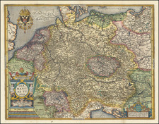
Antique Map of the Duchy of Bavaria in the early 17th Century
Nice old color example of Willem Blaeu's detailed regional map of the Ducal Region of Bavaria, during the reign of Maximillian I.
The map is centered on Munich and the courses of the Iser and Inn Rivers, as they flow toward the Danube in the north, flowing through Ingolstadt, Regensburg, and Passau and extending to the Alpine cities of Fussen, Partenkirchen, Innsburck and Saltzberg in Austria.
History of Bavaria
The Ducal region of Bavaria dates back its establishment in the southeastern part of the Merovingian kingdom from the 6th to 8th century. Settled by Bavarian tribes, it was under the control Frankish and ruled locally by Dukes. The duchy was re-created at the end of the Carolingian Empire (9th century) and became a duchies of the East Frank which would become the Kingdom of Germany and the Holy Roman Empire.
Between 1070 and 1180 the Holy Roman Emperors were again strongly opposed by Bavaria, especially by the ducal House of Welf. In the final conflict between the Welf and Hohenstaufen dynasties, Duke Henry the Lion was banned and deprived of his Bavarian and Saxon fiefs by Emperor Frederick Barbarossa. Frederick passed Bavaria over to the House of Wittelsbach, which held it until 1918. The Bavarian dukes were raised to prince-electors during the Thirty Years' War in 1623.
Maximilian I of Bavaria established a unity and order in the duchy which enabled Maximilian to play an important part in the Thirty Years' War; during the earlier years of which he was so successful as to acquire the Upper Palatinate. Maximilian retained these gains at the Peace of Westphalia in 1648. In 1632 the Swedes invaded, and when Maximilian violated the treaty of Ulm in 1647, the French and the Swedes ravaged the land. After repairing this damage to some extent, the Maximilian died at Ingolstadt in September 1651, leaving his duchy much stronger than he had found it.
Willem Janszoon Blaeu (1571-1638) was a prominent Dutch geographer and publisher. Born the son of a herring merchant, Blaeu chose not fish but mathematics and astronomy for his focus. He studied with the famous Danish astronomer Tycho Brahe, with whom he honed his instrument and globe making skills. Blaeu set up shop in Amsterdam, where he sold instruments and globes, published maps, and edited the works of intellectuals like Descartes and Hugo Grotius. In 1635, he released his atlas, Theatrum Orbis Terrarum, sive, Atlas novus.
Willem died in 1638. He had two sons, Cornelis (1610-1648) and Joan (1596-1673). Joan trained as a lawyer, but joined his father’s business rather than practice. After his father’s death, the brothers took over their father’s shop and Joan took on his work as hydrographer to the Dutch East India Company. Later in life, Joan would modify and greatly expand his father’s Atlas novus, eventually releasing his masterpiece, the Atlas maior, between 1662 and 1672.
![(Second World War - Occupation of Germany) Карта Группировки Союзных Оккупационных Войск в Германии по УКА ГСОВ в Германии [Map of the Grouping of the Allied Occupation Forces in Germany according to the UKA GSOV in Germany] | Административное Деление Германии на 1 июня 1939 Года [Administrative Division of Germany on June 1, 1939]](https://storage.googleapis.com/raremaps/img/small/72174.jpg)
![[Fascist Organizations of Germany] Фашистские Организации Германии](https://storage.googleapis.com/raremaps/img/small/67801.jpg)