|
||

|

|
|

|
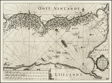
Antique map of Saaremaa and the Estonian Coastline.
Striking example of the antique sea chart of the Gulf of Riga, along the Latvia-Estonia border.
Includes sea monsters, sailing ships, a compass rose, and decorative cartouches, soundings, and anchorages. Profiles of the coast are shown.
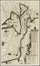
Wagenhaer was a Dutch pilot who produced the first set of effective navigational charts, under the title Spiegel der Zeevaerdt. These gorgeous charts, engraved by Baptist and Jan van Doetecum, embody the latest contemporary knowledge of navigation and position finding and set the standard which was followed for more than a century. Waghenaer's charts are magnificent works of art, which are highly sought after by collectors. An essential map for collectors of the region and the earliest decorative sea chart of the region.
![[ Duchy of Warsaw ] Polen im Herzogthum Warschau und unter Oestreich und Russland getheilt](https://storage.googleapis.com/raremaps/img/small/98514.jpg)