
This item has been sold, but you can enter your email address to be notified if another example becomes available.


|
||

|

|
|

|
Stock# 60775
Description
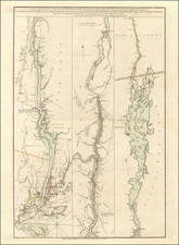
Antique Sea Chart of Puget Sound, Straits of Juan de Fuca and Gulf of Georgia -- Seattle / Vancouver
Rare antique sea chart of the region centered on the Strait of Juan De Fuca and showing the region north to Nanoose Bay and Burrard's Bay in the Gulf of Georgia, and south to include Puget Sound and Gray's Harbor.
Seattle is shown along with West Seattle, the West Point lighthouse near Ballard, Tacoma, Port Madison, Bainbridge Island, Port Gamble, etc.
A number of Indian villages appear on the map.
The chart shows lighthouses, islands, harbors, points, soundings, rivers, towns, etc. and includes sailing details and directions.

![[ Pacific Coast Pictorial Road Maps ] Scenic Touring Scout](https://storage.googleapis.com/raremaps/img/small/101745.jpg)
