|
||

|

|
|

|
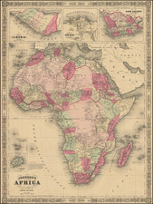
Striking Map of Africa, from Münster’s Renowned Cosmographia
Fine example of Münster’s second map of Africa, from his important Cosmographia.
This map replaced Münster’s boxier depiction of Africa in 1588. It was based on Abraham Ortelius’ influential map of 1570. Ortelius’ map, in turn, was based on Gastaldi's eight-sheet wall map of 1564 and Mercator's world map of 1569.
The map shows the continent of Africa, framed by Madagascar, the Arabian Peninsula, and part of Brazil. Unlike Ortelius’ map, part of Europe is also included on this map. Mountains, rivers, and large lakes dot the interior, along with cities and the names of political units, empires, and kingdoms. In the surrounding seas, there are sea monsters and ships. A simple title cartouche is in the Atlantic.
The main branch of the Nile is sourced from two lakes in southern Africa. The larger of these rivers is also the source for more rivers that flow south. All the rivers are amalgamated here, reflecting the common Medieval belief that most continents had a central lake which gave rise to the largest rivers of the landmass.
Münster's Cosmographia was the first German-language description of the world, and one of the defining books of the Renaissance. It contained 471 woodcuts and 26 maps over six volumes. First published in 1544, the Cosmographia was hugely popular in addition to being influential for contemporary cartographers like Mercator and Ortelius. It was published in at least 35 editions by 1628; these editions included examples in Latin, French, Italian, English, and Czech. After Münster's death, Henri Petri, and later his son, Sebastien Petri, took charge of printing editions.
Münster drew from his own travels in the work in addition to using other ancient and more modern sources. These sources included Herodotus, Strabo, and Titius Livius, as well as Marcantonio Sabellico, Beatus Rhenanus, and Aegidius Tschudi. Münster additionally collected reports from recent travelers, which he integrated into his descriptions. These descriptions generally included detailed overviews of the customs, dress, and organization of peoples around the world, earning him a prominent place in the histories of geography and anthropology.
The cartography of Africa to ca. 1570
Medieval mapping of the African continent was tied to the Christian worldview. Traditionally, the known world of Antiquity, which included the north of Africa, Asia, and Europe, was arranged symbolically in what is known as a T-O map. Such world images were common in Medieval manuscripts and they show the three landmasses in a T shape with an O, the ocean, surrounding them. The T-O maps are east-oriented—Paradise and Eden were supposedly located to the east—and some have Jerusalem at their center. Europe is in the bottom left corner and Africa the bottom right.
Over the course of the Medieval period, mappaemundi on the T-O model were increasingly stuffed with new place names and features, particularly those mentioned in the popular travel narratives of Marco Polo and Sir John Mandeville.
From roughly 1200, portolan charts showed increasing portions of the African coast. Meant for maritime navigation, these charts contained little to no information about the interior of the continent. They did, however, reflect the advancement of European, particularly Portuguese ships south along on the west coast of Africa. The culmination of these voyages was in 1498, when Vasco da Gama rounded the Cape of Good Hope and reached the Indian subcontinent.
Da Gama’s forging of an all-water route to India was particularly illuminating when compared with the prevailing geographic theories of the day, which were dominated by work of the second-century AD Alexandrian scholar, Claudius Ptolemy. Ptolemy postulated in his famous work, Geographia, that the Indian Ocean was enclosed by land which stretched from the south of Africa to southeast Asia. Early modern scholars were already questioning Ptolemy, however, even before da Gama reached India. For example, the Fra Mauro map has a peninsular southern Africa with a waterway flowing around it.
Early printed editions of Ptolemy—the first with maps was printed in 1477 in Bologna—would increasingly include tabula nova, or new maps, which supplemented Ptolemy’s ideas with more modern observations. The first edition to include the Portuguese discoveries in Africa was the Rome edition of 1508. The first surviving printed map to include the discoveries was the earlier Contarini-Roselli world map of 1506, the only surviving example of which is at the British Library.
Martin Waldseemüller’s 1507 world map, the sole example of which is now at the Library of Congress, also shows the revised version of the continent. Additionally, Waldseemüller included the new discoveries in his Africa maps for an edition of Ptolemy published in 1513. The first modern map of the entire African continent was in Sebastian Münster’s edition of the Geographia published in 1540 (and his Cosmographia of 1544). After Münster, Ortelius’ 1570 map was the first widely-distributed map of the continent and it would popularize the ideas of Giacomo Gastaldi, his main source. It also inspired other maps, like the second map of Africa included in later editions of the Cosmographia.
Gastaldi lived in Venice and had collaborated with Ramusio on his famous travel collection, which gave Gastaldi access to the latest geographic knowledge. In his important, yet not widely distributed, 1564 map of Africa, Gastaldi corrected the southwest coast, which was typically sloped too steeply. He also introduced a novel depiction of the sources of Africa’s rivers. Finally, he drastically increased the number of place names included: 655 names along the coast and a whopping 1200 in the interior.
Ortelius and those who followed him retained many of these place names, although he shifted some to new locations. In some cases, as with the names of lakes, he largely used his own names. He also scaled down the level of ornamentation and decoration drastically as compared to the 1564 map. Ortelius also corrected Gastaldi by narrowing the point of the Cape of Good Hope and reduced the extension of the continent to the east. These adjustments made Ortelius’ map far closer to the actual east-west, north-south size of the continent; it was the most accurate map of Africa to date.
The cartography of Central Africa and the source of the Nile
The innovative depiction of the African river systems in Gastaldi and Ortelius are notable for their divergence from previous models and for their importance as a model for future mapmakers. Typically, mapmakers thought the Nile River rose from twin lakes south of the equator, which were near the Mountains of the Moon. Streams from the mountains fed the lakes. Ptolemy describes such a lakes-and -mountains layout in his works, although the precise identification of the Mountains of the Moon may have been a fourth century addition to his text.
Sixteenth century mapmakers, including Waldseemüller and Münster, chose to follow the Ptolemaic model. This was typical of cartographers at the time, who had abandoned Ptolemy’s coastlines in favor of the more recent Portuguese outlines yet who also clung to Ptolemaic place names for the interior of Africa well into the nineteenth century.
Gastaldi, most likely thanks to sources he read via Ramusio, chose to abandon the Mountains of the Moon entirely. Instead, he drew a massive central lake from which flows the Nile, Zaire (Congo), Cuama (Zambezi), and Spirito Sancto (Limpopo) Rivers. To the east is another, smaller lake at roughly the same latitude, which also feeds part of the Nile. Therefore, Gastaldi created an entirely different view of the interior of Central Africa, while still embracing Ptolemy’s twin lakes theory.
Sebastian Münster (1488-1552) was a cosmographer and professor of Hebrew who taught at Tübingen, Heidelberg, and Basel. He settled in the latter in 1529 and died there, of plague, in 1552. Münster made himself the center of a large network of scholars from whom he obtained geographic descriptions, maps, and directions.
As a young man, Münster joined the Franciscan order, in which he became a priest. He then studied geography at Tübingen, graduating in 1518. He moved to Basel, where he published a Hebrew grammar, one of the first books in Hebrew published in Germany. In 1521 Münster moved again, to Heidelberg, where he continued to publish Hebrew texts and the first German-produced books in Aramaic. After converting to Protestantism in 1529, he took over the chair of Hebrew at Basel, where he published his main Hebrew work, a two-volume Old Testament with a Latin translation.
Münster published his first known map, a map of Germany, in 1525. Three years later, he released a treatise on sundials. In 1540, he published Geographia universalis vetus et nova, an updated edition of Ptolemy’s Geographia. In addition to the Ptolemaic maps, Münster added 21 modern maps. One of Münster’s innovations was to include one map for each continent, a concept that would influence Ortelius and other early atlas makers. The Geographia was reprinted in 1542, 1545, and 1552.
He is best known for his Cosmographia universalis, first published in 1544 and released in at least 35 editions by 1628. It was the first German-language description of the world and contained 471 woodcuts and 26 maps over six volumes. Many of the maps were taken from the Geographia and modified over time. The Cosmographia was widely used in the sixteenth and seventeenth centuries. The text, woodcuts, and maps all influenced geographical thought for generations.
![[ Air Travel Routes in Africa ] Ministre de l'air regie Air Afrique](https://storage.googleapis.com/raremaps/img/small/89402.jpg)