


|
||

|

|
|

|
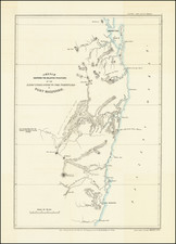
Rare regional map of New South Wales, published in the late editions of Thomson's General Atlas.
The map shows early exploration routes from Pt. Macquarie to Mt. Forster and the Macquarie River, from Newcastle to Cumberland County and from Argyle County to the apparent source of the Lachlan River, centered generally on Sydney.
A large inset show the British settlements at Port Jackson, including the roads into the interior as far as Windsor, Richmond, and the Nepean River, including names of the roads and mileage. The large inset of Van Dieman's land shows the 23 Districts as then established, plus much other detail.
A remarkable early maps, showing he tracks of Oxley & Evans in 1817-18 and Howe from Windsor to the Patterson River.
Tooley identifies the map as being by Aspin, and identifies it twice as plate 174 and 199.
John Thomson (1777-ca. 1840) was a commercial map publisher active in Edinburgh. He specialized in guide books and atlases and is primarily known for his Atlas of Scotland (1832) and the New General Atlas, first published in 1817 and reissued for the next quarter century. The New General Atlas was a commercial success—it was also published in Dublin and London—and it compiled existing geographic knowledge in compelling ways for a wide audience.
His Atlas of Scotland introduced new geographic information and was the first large-scale atlas of Scotland to be organized by county. It provided the most-accurate view of Scotland available before the Clearances. Work on the atlas began in 1820 and led to Thomson’s bankruptcy in 1830 due to the high costs of gathering the latest surveys and reviewing the required materials. Despite the publication of the atlas, Thomson declared bankruptcy again in 1835.
![[ Western Australia ] Carte de la Terre D'Edels et d'une partie De Celle D'Endracht (a la Nouvelle Hollande) Dressee Par M. L. Freycinet, Commandans la Goelette le Casuarina. (1801 & 1803) (Rare Separately Published Example)](https://storage.googleapis.com/raremaps/img/small/53267.jpg)
![Western Australia containing the Settlements of Swan River and King George's Sound… [with ] Van Diemen Island](https://storage.googleapis.com/raremaps/img/small/99485.jpg)

![[ Australia & New Zealand ] La Nuova Guinea e Nuova Galles](https://storage.googleapis.com/raremaps/img/small/86442.jpg)