|
||

|

|
|

|
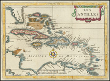
Fine Original Color Example of this Separately-Issued Map of Saint Domingue and its Environs
Finely detailed map of Saint Domingue and the surrounding seas by the famous French mapmaker Jean-Baptiste Bourguignon d’Anville. This is a separately-issued example of the map, which was also used as a book illustration; the present state, without a page number, is seldom seen.
The map shows the entire island of Hispaniola, split into Spanish-controlled Santo Domingo and French-controlled Saint Domingue. To the east is Puerto Rico, to the north the Cayoues and Turques, today known as the Turks and Caicos Islands. To the west, from north to south, is a large pracel, or submerged bank, the eastern tip of Cuba, and part of Jamaica.
Each of these islands are drawn with their principal settlements, usually clustered along the shore. The larger land masses also show streams and hills. At sea, in addition to the pracel, other navigational obstructions, like sand bars, are marked. North of Saint Domingue, several routes are included to allow for travel between the islands.
A floral cartouche in the upper right corner contains the title and date the map was completed, October 1730. Four scales are included below the cartouche. Under these is a note explaining that, while a dotted line separates the French and Spanish parts of Hispaniola, the actual border is not yet set. The dotted line should therefore be understood as provisional at best.
D’Anville’s Saint Domingue sources
Although initially colonized by the Spanish, the French took over the western third of the island of Hispaniola in 1697 with the Treaty of Rijswijk, only three decades before this map was drawn. As in the rest of the Caribbean, they developed large-scale plantations worked by enslaved Africans, with coffee plantations in the interior and sugar on the northern plains. The slave regime in Saint Dominque is considered by scholars as one of the most extreme. Slave mortality was high and violence common; the French imported over 800,000 men and women to the colony, practically double the total number imported to North America. This economic system built on the forced labor of thousands made Saint Domingue the most lucrative colony in the world.
D'Anville was well known for being the most erudite and meticulous mapmaker of his time. He was not content to reprint the work of others; rather he had to study all available materials and then make his own representations from scratch. In this case, he identifies several sources in the cartouche. The first of these is Amédée-François Frézier, a French military engineer and spy. Although best known today for introducing the strawberry to Europe from the Americas, Frézier was also a respected savant. His military superiors chose him to travel to Chile and Peru. There, he passed himself off as a tourist in order to covertly review the Spanish fortifications.
After this successful first trip to the Americas, which resulted in a celebrated voyage account, Frézier was then made Engineer-in-Chief to Hispaniola. While there, from 1719-1728, he made maps of the island and a plan of the city of Santo Domingo, among other cartographic outputs. D’Anville used the former island maps when drawing the present work.
The other source D’Anville mentions is a Mr. Buttet. The Bibliotheque Nationale has a plan of Santo Domingo dated 1717 (https://gallica.bnf.fr/ark:/12148/btv1b59728051). This was completed by Louis Marin Buttet de la Riviére, who first visited the then Spanish-controlled island in the late seventeenth century. A military officer, Buttet returned to the island in 1710 and became a landowner there. While serving in the military, he drew several maps and plans of the island, which D’Anville, in his position as a government-employed cartographer, would have been able to access.
This map is a rare separately-issued example; most surviving examples include a page number in the upper right-hand corner. This is because the map was included in Father Pierre François Xavier de Charlevoix’s Histoire de L’Isle Espagnole ou de S. Domingue, the first volume of which was published in Paris in 1730. The present map was meant to be bound at the beginning of the second volume, published in 1731.
Jean-Baptiste Bourguignon d’Anville (1697-1782) was one of the foremost French geographers of the eighteenth century. He carried out rigorous research in order to create his maps, which greatly developed the technical proficiency of mapmaking during his lifetime. His style was also simpler and less ornate than that of many of his predecessors. It was widely adopted by his contemporaries and successors.
The son of a tailor, d’Anville showed cartographic prowess from a young age; his first map, of Ancient Greece, was published when he was only fifteen years old. By twenty-two, he was appointed as one of the King’s géographes ordinaire de roi. He tutored the young Louis XV while in the service to the Crown. However, royal appointment did not pay all the bills, so d’Anville also did some work for the Portuguese Crown from 1724. For example, he helped to fill out Dom João V’s library with geographical works and made maps showing Portugal’s African colonies.
D’Anville disapproved of merely copying features from other maps, preferring instead to return to the texts upon which those maps were based to make his own depictions. This led him to embrace blank spaces for unknown areas and to reject names which were not supported by other sources. He also amassed a large personal map library and created a network of sources that included Jesuits in China and savants in Brazil. D’Anville’s historical approach to cartography resulted in magnificently detailed, yet modern and academic, maps. For example, his 1743 map of Italy improved upon all previous maps and included a memoir laying out his research and innovations. The geographer also specialized in ancient historical geography.
In 1773, d’Anville was named premier géographe de roi. In 1780, he ceded his considerable library to the Ministry of Foreign Affairs to be used for as a reference library for diplomats. D’Anville is best known for several maps, including his map of China, first published in 1735, and then included with Du Halde’s history of that country (the Hague, 1737). His map of Africa (1749) was used well into the nineteenth century.
![[ Charleston, Boston, New York, St. Augustine, Bahamas, etc ] Particular Draughts of some of the Principal Towns and Harbours belonging to the English French and Spanish in America and the West Indies.](https://storage.googleapis.com/raremaps/img/small/102804.jpg)

![[Rare Blaeu West Indische Pascaert Wall Map Section] Insulae Americanae in Oceano Septentrionali, cum terris adjacentibus](https://storage.googleapis.com/raremaps/img/small/75672.jpg)