|
||

|

|
|

|
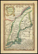
An American Rarity, Celebrating the Invasion of Canada in 1775.
Charming engraved map depicting “the Great Warpath” linking Lake George, Lake Champlain, the Sorel River and the St. Lawrence. This route between Quebec and the interior of the American colonies was of great strategic import to the American Rebels. During the first year of the Revolution it was, along with Boston, the most important theater of conflict.
In May 1775 a tiny force under Ethan Allen and Benedict Arnold captured the British forts at Crown Point and Ticonderoga, seizing the cannon that ultimately enabled General Washington to drive the British from Boston. In the Fall of 1775, the Americans invaded Quebec with a small force under Philip Schuyler, hoping to detach Quebec’s mostly French inhabitants from the British Empire. The Americans captured both St. Johns and Montreal, but the invasion ended with a disastrous defeat at Quebec, in which General Montgomery was killed.
The map depicts the region between the southern end of Lake George and the juncture of the Sorel and St. Lawrence Rivers, with coverage west to Montreal. The map is the first map published in America to depict this region in detail. It locates five major forts (Ticonderoga, Crown Point, St. John, Chambly and Montreal) and identifies several major land owners.
The map appeared in the October 1775 issue of The Pennsylvania Magazine, which featured a long “Geographical and historical Account of Lake Champlain, and the Country and Forts in its Environs.”
![[Portland & Cape Elizabeth to Moskito Island -- Centered on Kennebec River]](https://storage.googleapis.com/raremaps/img/small/50079.jpg)
![Belgii Pars Septentrionalis communi nomine Vulgo Hollandia…[Inset Views of New Amsterdam (New York City) & Batavia and Maps of NE United States and SE Asia]](https://storage.googleapis.com/raremaps/img/small/78398.jpg)