


|
||

|

|
|

|
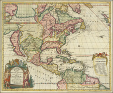
Rare 1704 Leiden Edition
Rare 1704 Leiden edition of Hennepin's highly important map of North America, from his Nouvelle Decouverte d'un Tres Grand Pays, which were described by Karpinski as " remarkable improvements" from the then best available modern maps for the Great Lakes.
Fr. Louis Hennepin, a member of the Recollect Order of Franciscans, accompanied Rene-Robert de LaSalle on part of his journey down the Mississippi in 1682. LaSalle was hoping to reach the Pacific Ocean, but instead ended up in the Gulf of Mexico, thereby adding a large slice of North America to French claims west of the Appalachians, well away from the threat of British colonists. Later, the French would use this expedition as the basis for claiming all of the land between the Rio Grande and Mississippi River as belonging to France, a claim which would not be resolved until the Adams-Onis Treaty in 1819.
The map provides an excellent summary of the state of knowledge of North America, at the beginning of the 18th century. Among other things, this beautiful map attempts to place into perspective Hennepin's mapping of the Great Lakes and the Mississippi River. Karpinski noted that Hennepin's delineations of Lakes Superior, Michigan and Huron are remarkable improvements upon the Sanson maps.
Hennepin produced two maps of North America for this work, this general map and a more regional map. This map's configuration of the Great Lakes and of the North American Coastline suggest reliance upon a different map than Hennepin's more regional map. Both maps, however, show the Mississippi River entering the Gulf far to the west of its actual location. Some historians believe this was done deliberately by La Salle to discourage colonization of the Gulf area by rival nations, by showing the lower Mississippi as Spanish territory.
Hennepin was one of the most popular chroniclers of the exploration of the American interior. Several books in numerous editions appeared under his name, although he was also given to sensational and unsupportable claims, such as his claim to have been first to the mouth of the Mississippi, ahead of LaSalle.
A seminal collectors map.
Rarity
First published in Amsterdam in 1698, this Leiden edition, which uses the original copperplate, was issued by Pierre Vander Aa, whose name appears in the cartouche, replacing A. von Someren's name.
![Oceani Occidentalis Seu Terrae Novae Tabula [The Admiral's Map]](https://storage.googleapis.com/raremaps/img/small/102935.jpg)
![[French & Indian War] Carte Des Possessions Francoises et Angloises dans le Canada et Partie de la Louisiane . . . 1756](https://storage.googleapis.com/raremaps/img/small/94026.jpg)


![A New and Correct Map of North America with the West India Islands, Divided According to the Last Treaty of Peace ... 20th of Jan. 1783 ... Particularly Distinguished the Thirteen Provinces which Compose the United States . . . [With annotations describing Cumberland, Tennessee, Kentucky etc.]](https://storage.googleapis.com/raremaps/img/small/41651.jpg)