|
||

|

|
|

|
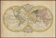
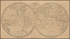
An Important Medieval World Map
Fine example of the earliest edition of Macrobius' important Medieval world map, first published in Brescia in 1483. The present example is from a 1524 printing of Macrobius' In Somnium Scipionis exposito, with the cartographic content reversed (Britain is at the top right).
The works of the late Roman philosopher and grammarian Macrobius (c.395-436) were very popular during the Middle Ages. "His neoplatonic commentary on Cicero [the `Dream of Scipio' from Book VI of De Republica], includes among many references to the pseudo-sciences, a geographic concept which is different from that of Ptolemy. The inhabited World north of the Equator is balanced by a southern continent and divided by water'' (Shirley).
As noted by Shirley:
The inhabited world north of the Equator is balanced by a southern continent and divided from it by water. Among the roughly 150 manuscripts recorded by Destombes dating from 1200 to 1500 AD nearly 100 contain a simple map illustrating Macrobius's theories.
The first printed edition of Macrobius appeared in 1483, published in Brescia. Four different woodblock early examples of the map are known, as follows:
- Block 1: Brescia (1483, 1485 and 1501)
- Block 2: Venice 1489
- Block 3: Venice 1492
- Block 4: Venice 1500
Later printings in 1521, 1528, 1568 and 1574 appear more frequently on the market. A 1535 Basel edition exists with a more modern outline of Africa shown.
The present example is accompanied by a copy of the book in a decorative leather binding.
Collation: Aviii, [aviii-rviiii], [svi]; [Aavi], [Aviii-Oviii]; [Aax]