|
||

|

|
|

|
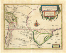
The German Colonies of Rio Grande Do Sul
Rare separately published map of the Brazilian State of Rio Grande do Sul, published in Porto Alegre by the firm of Joaquim Alves Leite.
The map includes inset maps of the following regions, primarily early German colonies:
- Porto Alegre and VicinityRio Guahyba
- Ex Colonias S. Leopoldo e Nova Petropolis
- Ex Colonias Alfredo Chaves, Antonio Prado, Caxias, D. Izabel, Conde D'Eu
- Ex Colonia Sant' Angelo
- Ex Colonia Silv. Martins
- Ex Collonia Santa Cruz
- Ex Colonia Mont Alverne
- Ex Colonia S. Feliciano
The map highlights the surveys conducted by the military engineers João Candido Jacques and Alfredo Vidal, presenting a fine general cartographic overview of the numerous German Colonies that, since 1824, had been established across the state, and which had a transformative impact upon the region’s economy and culture.
Relying upon the trigonometric surveys of the period, the map emphasizes the topography of the region, with ranges of mountains and hills shaded, while all coastlines, rivers, lakes and marshlands are carefully delineated. The ‘Convenções’, or table of signs, lower-centre, describes the symbols used to denote settlements of various sizes; churches; forts; railway lines (both operational and under construction); roads; boundary markers; lighthouses; bridges; mountain passes; shipping lanes; telegraph line routes; mines; boundary lines, and well as abbreviations used for a variety of topographical features.
A ‘Lista de lugares do estado onde existem agencias do Correio e Estações Telegráphicas’, lists all major cities and towns in the state and denotes whether they have post offices and telegraph stations. At the right side, a ‘Lista das Estradas de Ferro’, describes the mileages between stations along each of Rio Grande do Sul’s three railway lines.
From 1824 to 1885, the Brazilian government established numerous land grants in Rio Grande do Sul specifically earmarked for immigrants from Germany. Throughout the 19th Century, Rio Grande do Sul, saw a large flows of German settlers. By 1891, German immigrants had been largely responsible for transforming Rio Grade do Sul from a frontier backwater into one of Brazil’s most affluent regions. It also ensured that German architecture, customs, festivals, food and drink had become a mainstream part of the local society.
Map Maker
Major João Candido Jacques (b. 1854, fl. 1870 - 1912) was a Brazilian military engineer and artillery officer. He had previously completed a masterful survey of Port Alegre, Planta de Porto Alegre Capital da Provincia do Rio Grande do Sul (Porto Alegre: Joaquim Alves Leite, 1888),.
Rarity
The map is very rare. We can locate only 4 institutional examples (Biblioteca Nacional do Brasil; University of California, Berkeley Library; Cambridge University Library, and at the National Archives UK).