
The item illustrated and described below is sold, but we
have another example in stock. To view the example which
is currently being offered for sale, click the
"View Details" button below.


|
||

|

|
|

|
Stock# 60576
Description
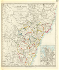
Detailed map of New South Wales, based upon information at the Colonial office.
Shows towns, rivers, mountains, lakes, roads, islands, etc. Inset plan of Sydney.
The Society for the Diffusion of Useful Knowledge was active from the 1830s through the 1860s and published some of the best regional maps of the era.
![[Tasmania] Van-Dieman's Land](https://storage.googleapis.com/raremaps/img/small/71538.jpg)
![Asia [with inset:] New Holland or Australia.](https://storage.googleapis.com/raremaps/img/small/98818.jpg)
![[ New South Wales Electors in 1871 ] Map Shewing Roads & Postal Stations in New South Wales Prepared for the Use of the Post Office Department](https://storage.googleapis.com/raremaps/img/small/88237.jpg)
![(Australia) Australien - Ubersicht des Standpunkets der geographischen Kenntniss von Australien, 1868, & Dr. Neumayer's Projeket zur wisseschaftlichen Erforschung Central-Australiens [Survey of the Standpoint of the Geographical Knowledge of Australia, 1868, & Dr. Neumayer's project for the scientific investigation of central Australia]](https://storage.googleapis.com/raremaps/img/small/85398.jpg)