


|
||

|

|
|

|
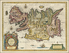
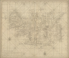
The Most Important Map of Iceland After Ortelius and Mercator - Reynir Grétarsson, Author of Mapping Iceland
Finely colored example of the Carolus map of Iceland, published by William Janszoon Blaeu in the first half of the 17th century. This is a stunning map, including an erupting volcano, sea monsters, sailing ships, decorative cartouches, compass rose, and the spectacular landscape of Iceland.
Originally published by Jodocus Hondius, and reprinted using the same plates by Blaeu, this map updates the earlier Mercator map of the island which had become overused. The map credits Joris Carolos, who had personally visited Iceland, as its source, though it seems that Blaeu also reused a number of toponyms from the earlier Ortelius map. The map includes a number of new islands and fords, some of which are fictional, although little change appears in the interior of the island.
The motivation for the creation of this map appeared to be to create something new for consumers who were tired of the repetitive appearance of the same two maps. However, this quest for newness apparently did little for accuracy (Gretarsson). Despite this, Hondius's (later Blaeu's) map was copied by many others for a long time following its publication.
Willem Janszoon Blaeu (1571-1638) was a prominent Dutch geographer and publisher. Born the son of a herring merchant, Blaeu chose not fish but mathematics and astronomy for his focus. He studied with the famous Danish astronomer Tycho Brahe, with whom he honed his instrument and globe making skills. Blaeu set up shop in Amsterdam, where he sold instruments and globes, published maps, and edited the works of intellectuals like Descartes and Hugo Grotius. In 1635, he released his atlas, Theatrum Orbis Terrarum, sive, Atlas novus.
Willem died in 1638. He had two sons, Cornelis (1610-1648) and Joan (1596-1673). Joan trained as a lawyer, but joined his father’s business rather than practice. After his father’s death, the brothers took over their father’s shop and Joan took on his work as hydrographer to the Dutch East India Company. Later in life, Joan would modify and greatly expand his father’s Atlas novus, eventually releasing his masterpiece, the Atlas maior, between 1662 and 1672.
![[ Iceland ] Isola d'Islanda](https://storage.googleapis.com/raremaps/img/small/98962.jpg)