


|
||

|

|
|

|
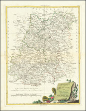
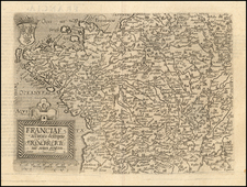
Rare early regional map of France, extending form Isle D'Oleron to the Seure River and Lusson, centered on Isle de Re.
The map includes multiple sailing vessels and an ornate compass rose.
The map is based upon a locally published map by Jerome Bachot (1596-1635?). At the center right, the city of Saint-Jean-d’Angely, a protestant stronghold during the Wars of religion appears, with two roads leading to it from the west.
The map appeared in Tavernier's rare Théâtre géographique du royaume de France.
Melchior Tavernier was a member of a large family involved in the publishing trade in Paris in the early years of the seventeenth century. Early in his career, he apparently collaborated with Henricus Hondius, as at least one of his early maps references Tavernier as the seller of a map engraved in Amsterdam, by Hondius. He is probably best known for his publication of a map of the Post Roads of France, which was copied many times until the end of the century. He also issued an atlas under the same title as J. le Clerc's Theatre Geographique, using many of Le Clerc's maps, but incorporating others from different sources. He published composite atlases and also published works for other cartographers, including N. Sanson, N. Tassin, and P. Bertius. He is not to be confused with his nephew of the same name (1594-1665), who also engraved maps for Nicolas Sanson.
![[Portrait of Louis XV as a child] Ludovicus XV. Franciae et Navarrae Rex Natus 15 Febr. Anno 1710.](https://storage.googleapis.com/raremaps/img/small/95867.jpg)
![[Bay of Biscay] Paskaerte Vande Bocht van Vranckrijck Biscajen en Galissen tuscchen Heylant en C. de Finisterre](https://storage.googleapis.com/raremaps/img/small/83967.jpg)