


|
||

|

|
|

|
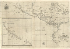
The First Sea Chart Focused on the Coast of California
Rare first edition of the earliest map to focus on the California Coast, published in Florence by Robert Dudley.
The map appeared in Dudley's landmark sea atlas, the Arcana del mare, the first sea atlas published by an Englishman and the first sea atlas to attempt to portray the entire globe. The map is curious mix of Spanish and Portuguese place names and shows the enormous and fictitious Golfo Profondo.
The inset map shows a straight east-west coast north of Mendocino, which is similar to Briggs map, although Leighly notes that Dudley followed the nomenclature in Daniell's map, which is thought to have been based upon the official map of Vizcaino's voyages and did not treat California as an island.
Many early place names shown, including references to Drake, Monterrey and San Diego.
The main map includes excellent detail in the tip of Florida and the Caribbean, including Cuba, Hispaniola, the Bahamas, Jamaica and an a nice depiction of the Cayman Islands (Caimane Grande and Caimanes). Excellent coastal detail in Central America.
Attractive compass rose, sailing ship and cartouche.
Rarity
Dudley's maps are increasingly rare on the market. This is our second example in over 20 years.
Robert Dudley (1574-1649) is one of the most intriguing historical figures of the late Elizabethan period. His father, also named Robert and the first Earl of Leicester, was a favorite of Elizabeth I’s. The Earl was a supporter of exploratory expeditions and backed Francis Drake on his circumnavigation (1577-1580) and Martin Frobisher on his 1576 voyage to find the Northwest Passage. Robert the Younger was the illegitimate son of the Earl and Lady Douglas Sheffield, born in 1574.
Dudley attended Christ Church, Oxford, starting in 1587. A year later, at only 14, Dudley stood by his father at Tilbury, witnessing Queen Elizabeth’s famous speech in preparation for resisting the Spanish Armada. His father died in September that year, giving Robert a sizeable inheritance. In 1594, Dudley led an expedition to Guiana, where some of his men explored up the Orinoco River in search of gold. In 1596, Dudley joined an expedition against Cadiz.
All these experiences left Dudley in favor, and he thought the time was right to establish his legitimacy. In court proceedings from 1603 to 1605, Dudley fought for his right to his father’s titles, but the Star Chamber ruled against him and he had to leave England for self-exile in Italy. He settled in Florence, where he designed and built ships and advised Ferdinand I, Grand Duke of Tuscany.
While in Florence, Dudley also compiled all his sailing notes and thoughts on navigation (and those of others including, purportedly, Francis Drake, with whom he sailed in 1596, and Thomas Cavendish, to whom he was related by marriage) into a work called Arcano del Mare, or The Secret of the Sea. He finished the manuscript of the work in 1636 and published the work himself, at age 73, a decade later in 1646-7.
Dudley’s Arcano del Mare (Mystery of the Sea) is one of the most important atlases ever produced and one of the most complex. It is the first sea-atlas of the whole world; the first with all the charts constructed using Mercator's new projection, as corrected by Edward Wright; the first to give magnetic declination; the first to give prevailing winds and currents; the first to expound the advantages of Great Circle Sailing; and the first sea-atlas to be compiled by an Englishman, albeit abroad in Italy. Dudley broke completely with the contemporary style of charts. He showed lines of latitude and longitude and omitted all compass lines. In doing so, his purpose was more intellectual than practical: techniques for determining longitude at sea were not refined until more than two centuries later. The maps are by English and other pilots and it is generally accepted that the work was both scientific and accurate for the time. Dudley used the original charts of Henry Hudson, and for the Pacific Coast of America used Cavendish's observations. The Arcano del Mare was a monumental and totally original task; the charts, representations of instruments, and diagrams all engraved on huge quantities of copper over many years with an exactitude incorporating the minutest detail and printed on the best possible paper.
Antonio Francesco Lucini, the engraver, was born in Florence c. 1610. Before being employed by Dudley, he had already engraved views of Florence and scenes of the Turkish Wars. In a printed introductory leaf found in one copy in the British Library, Lucini states that he worked on the plates in seclusion for twelve years in a Tuscan village, using no less than 5,000 lbs (2,268 kg) of copper.
![[La Paz / Estero de Agiabampo / Santa Maria Cove] Ports of the Gulf of California](https://storage.googleapis.com/raremaps/img/small/73352.jpg)

![[California Wine Advertising Graphic] Italian Swiss Colony Producers of Choicest California Wines Asti Colony Tipo](https://storage.googleapis.com/raremaps/img/small/83467.jpg)
![[Los Angeles Olympic] O Limp Hicks Loose Anglaise Calif. 1932](https://storage.googleapis.com/raremaps/img/small/90509.jpg)