|
||

|

|
|

|
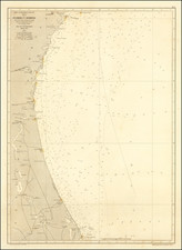
Rare American Sea Chart of the Gulf Coast, from Florida to the Mouth of the Mississippi
Rare sea chart of the coast from the Mississippi Delta to just east of Florida's Appalachicola Bay, published in New York by Edmund Blunt.
This chart was first published in 1828 as a replacement to the Blunts' 1815 Chart of the Mississippi River and the Coast of West Florida. It includes a coastal outline with names of major towns and landmarks, soundings and other hydrographic data, and shoals and other navigational hazards. Though broadly similar to its predecessor of 1815, it covers a longer stretch of coast and includes far more hydrographic data.
The present example is the 1834 reissue, with the addition of an inset showing the entrance to St. George's Sound.
As with Blunt`s 1815 chart, this is essentially a simplified version of the Gauld charts of the region from the 1760s and 1770s. By comparison, the Blunt chart provides a similar but "looser" rendering of the coast, and fewer soundings and other hydrographic data.
Rarity
The chart is extremely rare. Rumsey lists a copy of the 1828 edition, bound into a rare composite sea atlas. OCLC lists only the 1838 (Massachusetts Historical Society). We also note that Goodspeed's offered copies of the chart for sale in 1929 (1831 edition) and 1933 (1839 edition). The Mississippi State Archives includes a copy of the 1837 edition. The later editions were revised, with a different title and inset of the Main Entrance to St. George's Sound.
![[ Native American about to Murder A Frenchman in a Dugout Canoe ] Petri Gambie Galli Caedes](https://storage.googleapis.com/raremaps/img/small/97871.jpg)
![[ Florida Indians - Preparations for a Feast ] Conviviorum apparatus](https://storage.googleapis.com/raremaps/img/small/98462.jpg)