|
||

|

|
|

|
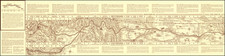
Fine Map Illustrating Baron Lahanton's Longue River
The map was prepared to illustrated Lahontan's imaginary west-east Long River (Riviere Longue), rising in distant western mountains and emptying into the upper Mississippi and the general region of Canada which he explored.
The map extends east to the Great Lakes to show Lac Superieur, and Lac de Illinois (Michigan), along with a number of the early French forts and fur trading outposts. Extensive annotations and diagrams throughout.
Lahontan's map was one of the most influential of all mythical cartographic works, effecting the cartographic landscape of the upper Mississippi, and the Plains and Rocky Mountain Regions, for nearly 50 years. Issued in Noueaux Voyages de M. le Baron de Lahontan dans l'Amerique Septentrionale, one of the most influential and fanciful works of its time. The map depicts the Longue flowing from the mountains in the west (Rocky Mountains), home to the Gnacsitares Indians, and connecting to the Mississippi River. On the western side of the mountains is another river, presumably flowing into the Pacific.
![[ The Old Northwest Territory ] Il Paese De Selvaggi Outagamiani, Mascoutensi Illinesi E parte Delle VI Naxioni](https://storage.googleapis.com/raremaps/img/small/75927.jpg)