This item has been sold, but you can enter your email address to be notified if another example becomes available.


|
||

|

|
|

|
Stock# 60135
Description
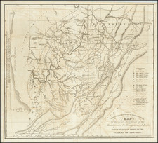
Ohio River in the 18th Century -- Gallipolis, Ohio to Glenwood, West Virginia
Fascinating hand drawn survey map of a 15 mile section of the Ohio River, by an unknown early surveyor.
The map shows the area including Gallipolis, Ohio and Point Pleasant, West Virginia. Distances along the map are shown in "poles."
The map is undated but would appear to have been prepared around 1800.
The map names 1760 acres owned by Charles Lewis near Point Pleasant, West Virginia.
Other towns now on the map include Gallipolis Ferry, Apple Grove, and Ashton, along the Ohio River.
Condition Description
Trimmed around the image and laid down on a large early sheet of paper.