|
||

|

|
|

|
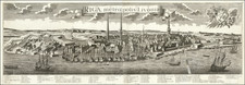
This is a small and well-engraved map of the fortress of Daugavgriva, located at the mouth of the Daugava River, just downstream from Riga. The map shows the fortress alongside an attractive title cartouche. An inset shows the region, including Riga, and German text describes the region.
The old star-shaped moat is still visible on the left bank of the Daugava in the present-day, adjacent to the Latvian Maritime Academy. Remains of the fort and other military activity are scattered throughout the area.
Daugravgriva fortress played a key role at several points throughout Latvian history. The fortress at its current site was built by the Poles after the Daugava changed course in the late 16th century. The fort changed hands several times over the seventeenth century and was eventually taken by Augustus II's campaign during the Great Northern War. Despite taking the fortress and renaming it Augustusburg (as noted on the map), he did not succeed in conquering Riga. After the war, the region came under Russian control until a German takeover in World War I, when it underwent a minor bombardment. Subsequently, the fort fell out of military use, although this area is used as the winter port of Riga.
Gabriel Bodenehr the Elder (ca. 1673-ca. 1766) was a German engraver and publisher. He originated views of many German cities, for example the first plan of Passau (1710), and is best known for his Atlas Curieux (1704). His son, Gabriel the Younger (1705-1779), followed his father in his profession and was also a well-known engraver.

![Livoniae Provinciae Ac Eivs [with] Moscoviae Maximi Amplissimi Que Ducatus](https://storage.googleapis.com/raremaps/img/small/65792.jpg)
![(Second World War - Eastern Front) [The Soviet Encirclement of Konigsberg]](https://storage.googleapis.com/raremaps/img/small/65659.jpg)
![[ Estonia, Latvia, Lithuania ] Ducatuum Estoniae et Livoniae Tabula cum cursu Fluvii Dwinae](https://storage.googleapis.com/raremaps/img/small/62142.jpg)