This item has been sold, but you can enter your email address to be notified if another example becomes available.


|
||

|

|
|

|
Stock# 59835
Description
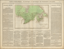
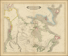
Rare early 19th Century map of Canada, from coast to coast, published in Germany.
The map focuses on the drainages of the various rivers and lakes, centered on the Win-ni-peg See. Includes excellent treatment of the Lakes and Rivers.
The map extends south to include the Missouri, Kansas and Arkansas Rivers, which meander to the Rocky Mountains. The tributaries of the Misury or Missury River, as it is spelled on the map, include Galatin, Madison and Jefferson.
The course of the Columbia flows due North, mimicking the Frasier River. Excellent detail in the NW parts of Canada, extending beyond Slave Lake.
Condition Description
Minor foxing.