


|
||

|

|
|

|
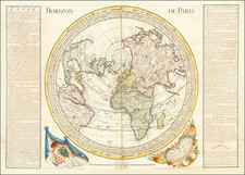
Rare, Detailed Hemisphere Maps by Covens & Mortier with the Latest Voyages
Fine pair of maps of the northern and southern hemispheres, originally by Guillaume Delisle, and revised and reissued by Covens & Mortier. This later edition is significantly rarer than the original edition of 1714, as well as the derivatives published by De Leth and others.
Each hemisphere is presented on its own sheet, with the round map filling the center. At the top, the title runs on either side of the circle, with additional text in French and Dutch below. A simple square border encompasses the entire text and map, an addition made by Covens & Mortier soon after they first started issuing this map around 1730. The text on the northern hemisphere is dated 1740, while Covens & Mortier are identified on the southern hemisphere.
Overall, there are two points of interest that a reader would notice right away. First, the hemispheric, circumpolar projection has the opposite effect of the more-common Mercator projection. The Mercator projection inflates land masses at the northern and southern poles while showing regions closer to the Equator in their correct proportion. This projection, conversely, shows the Polar regions correctly and distorts Equatorial areas.
The other detail of note is the presence of the vast empty spaces at both poles, as well in northwestern North America, portions of Australia, and New Zealand. These blank spaces were a major innovation by the original mapmaker, Guillaume Delisle. Unlike many of his contemporaries, Delisle preferred blank spaces to conjecture or decorative embellishment. If he did not know the shape of a coast, he left it out or at least marked it with a dotted line. This approach is emblematic of the more scientific approach to mapmaking adopted in the eighteenth century.
Northern Hemisphere:
Looking at the northern hemisphere, California is shown as a peninsula, albeit with a dotted line. This line is a nod to the one of the great cartographic blunders of the period, the creation of California as an island. At this time, many mapmakers showed the peninsula as insular. Although Father Eusebio had published his refutation of this trend in Paris in 1705, mapmakers were slow to revert back to the actual peninsular form. Guillaume Delisle was an early adopter of the correction, as shown here.
Across the Pacific, Japan, or Niphon as it is written here, is shown horizontally, a typical depiction for the time. To the northeast is an unfinished island called Terre de la Compagnie. A nearby note explains that the coast was discovered by Jean de Gama. This explanation actually elides two popular cartographic chimeras of the time. Juan de Gama, the grandson of Vasco de Gama, was a Portuguese navigator who was accused of illegal trading with the Spanish in the East Indies. Gama fled and sailed from Macau to Japan in the later sixteenth century. He then struck out east, across the Pacific, and supposedly saw lands in the North Pacific. These lands were initially shown as small islands on Portuguese charts, but they ballooned into a continent-sized landmass in later representations.
Several voyagers sought out de Gama’s lands, including the Dutchmen Matthijs Hendrickszoon Quast in 1639 and Maarten Gerritszoon Vries in 1643. Vries commanded the Castricum, while Hendrick Cornelisz Schaep was in charge of the Breskens. Compagnies Land, along with Staten Land, were islands sighted by Vries on his 1643 voyage. He named the island for the Dutch States General (Staten Land) and for the Dutch East India Company (VOC) (Compagnies, or Company’s Land). In reality, he had re-discovered two of the Kuril Islands. However, other mapmakers latched onto Compagnies Land in particular, enlarging and sometimes merging it with Gama’s island.
The text surrounding the hemisphere reveals one of the sources for this updated work, a map by Jean Kyrilow, Secretary of the Council of the Empire of Russia published in 1734. His map was used to provide a more complete outline of Kamchatka and northeast Russia than Delisle had included on his 1714 edition. A letter from a Dutch resident of St. Petersburg, a Mr. Swartz, is included in the lower portion of the border of this hemisphere.
Southern Hemisphere:
The Southern hemisphere is even more packed with information about recent voyages and European exploration, including an expedition that had happened only a couple of years before this revised edition was published.
Older voyages are also present, including two notes about Amerigo Vespucci. They explain how, on his third voyage, Vespucci and his crew sailed far to the south before being repulsed by a storm. Another famous sixteenth-century navigator is also mentioned, Ferdinand Magellan. Magellan is credited with the world’s first circumnavigation and, although his ship and some crew made it back to Europe, Magellan himself died in the Philippines.
The third sixteenth-century explorer on this map is Alvaro de Mendaña. Mendaña led a Spanish expedition to the Solomon Islands in 1567-9, but his crew forced his return to Peru. Another attempt was made from 1595-6 to return to the Solomons, but they had not been charted accurately. Mendaña died on Santa Cruz, leaving his wife in charge of the settlement they had started. She decided to return to Spanish dominions and they arrived in the Philippines in early 1596.
Pedro Ferdinand de Quiros sailed with Mendaña on his second voyage and his track is also shown on this hemisphere. After returning to Spain, he convinced authorities that he could find Terra Australis, the southern continent, if they gave him ships and supplies. He set out in 1605 and eventually landed on what is today Vanuatu. He mistook one of the islands for the fabled continent and called is Australia de Espiritu Santo; it features prominently on this map. Quiros intended to set up a colony, but his crew forced him to leave. Quiros returned to Mexico, but his second-in-command, Torres, sailed west, through the strait now bearing his name, which is not shown here because its existence was suppressed by the Spanish authorities.
A strait that could not be suppressed is the Strait of Le Maire, near Tierra del Fuego. Le Maire’s track is also shown. Cornelis Le Maire, along with Willem Schouten, circumnavigated via Cape Horn in 1615-1617, the first to sail round South America instead of through the Straits of Magellan. As the Straits of Magellan fell under the monopoly of the VOC, the route discovered by Le Maire and Schouten opened a new trade route to the Pacific.
The Australian continent is shown only with its east coast here and is marked with names from Dutch encounters with its rugged coast. For example, to the west is Terre de Wit, which recalls Gerrit Frederikszoon de Witt, captain of the Vianen, who sailed in 1628. To the west is Terre d’Endracht. The Endracht was the second recorded European ship to contact Australia (1616). Terre de Leuwin is named for the Leeuwin, whose crew charted some of the southwest coastline in 1622; Flinders would later name Cape Leeuwin, the southwestern most point on the Australian mainland, after the ship. Terre de Nuits is named for Pieter Nuyts, a Dutch navigator who commanded the Gulden Zeepaert along the southern coast in 1627.
Another feature of Australia included here is Van Diemen’s Land. It is near the eastern coastline of New Zealand. Both lands were first encountered by Europeans when Abel Tasman lead a Dutch voyage to discover new trading opportunities south of the East Indies. In the first of two voyages in the early 1640s, Tasman landed at Van Diemen’s Land, which was not known to be an island, and then, briefly, in New Zealand. He returned to Batavia, the VOC’s main trading port, via Papua New Guinea.
Another track near to Tasman’s in New Guinea belongs to an Englishman, William Dampier. Dampier was the first person to circumnavigate the world three times. The track here is during his first and only voyage for the Royal Navy, when he was tasked with discovering the southern continent. Having set sail in 1699 and ditched his lieutenant in Brazil, Dampier then sailed around the Cape of Good Hope, rather than Tierra del Fuego as originally planned, to New Holland. He coasted clockwise around New Guinea and named the island of New Britain before losing his ship to a leak at Ascension.
At the same time that Dampier was losing his ship, another English voyage was sailing in the South Atlantic, as also shown on this map. Edmund Halley was an astronomer. The English Royal Navy granted him command of a ship for three expeditions to measure magnetic variation, two to the South Atlantic in the late 1690s and one to the English Channel. He not only made scientific breakthroughs, but was also the first to extensively sail in the southern Atlantic, seeing mountains of ice, i.e., icebergs, en route.
There are many more details of note included here, such as the Dutch encounter with Rapa Nui, or Easter Island, in 1722. The most significant recent voyage, however, is that of Bouvet de Lozier, as explained in the title of this hemisphere. In the South Atlantic is a coast marked Cap de la Circoncision. This was part of an island found by Jean-Baptiste Charles Bouvet de Lozier in 1739. The Atlantic is criss-crossed by the tracks of the Marie and the Aigle, which were vessels he commanded. Bouvet was an employee of the French East India Company who was convinced that, given a chance, he could make discoveries around the South Pole, or near the much vaunted Terra Australis Incognita. In 1739, the Company gave him a chance. Bouvet meticulously searched the South Atlantic, but he had to return to France earlier than expected because his crew became too ill to continue. Unfortunately, he mislabeled the coordinates of Cap de la Circoncision and therefore the island was set in position only in 1808. Today it is known as Bouvet Island.
On this map, Bouvet’s route is the only one to be marked as a solid line, not a dotted one. The extra text outside the hemisphere is also dedicated to Bouvet. It contains an extract from his voyage journal describing icebergs and the encounter with Cap de la Circoncision. This island is shown in the inset map in the lower right corner.
Although obscure today, Bouvet’s voyage was big news at the time, as indicated by his prominence here. When this map was published, he was the most famous French explorer alive. The value placed on discovery and exploration is evident on both hemispheres, as is the importance of new and updated geographic knowledge.
Rarity and editions
There are several reissues of Delisle’s 1714 work by Covens & Mortier, as well as Hendrick de Leth, the Ottens, and others. However, this edition is the first to include significant additions and revisions as compared to the original. These additions include all the exploration information dated after 1714 and the text in French and Dutch in the borders.
Covens & Mortier first issued these maps, with the added simple border, in the early 1730s. This is their second edition, with the added text and updated information about Bouvet and Northeast Russia. The map was included in the Covens & Mortier editions of Delisle’s Atlas Nouveau, first issued in 1708 but released in newer editions, with more maps, in 1720, ca. 1721, 1730, 1731, 1733, 1735, 1737, 1740, and later. The hemisphere maps were also likely sold separately as evidenced by their presence in other composite atlases and atlases issued by other map dealers, as is the case in the example in the Rumsey Collection.
This state with the French and Dutch text is pointedly rarer than the original 1714 and de Leth editions, which contain less textual detail. It is a rare find seldom seen on the market in the previous three decades.
Johannes Covens (1697-1774) was a Dutch geographic publisher based in Amsterdam. He is best known for his collaboration with fellow publisher Cornelis Mortier (1699-1783). Pierre Mortier the Elder (1661-1711) had obtained a privilege in 1690 to distribute the works of French geographers in the Netherlands. After his widow continued the business for several years, Cornelis took over in 1719.
In 1721, Mortier forged a partnership with Covens, who had recently married Cornelis’ sister. They published under the joint name of Covens & Mortier. In 1774, upon the death of his father, Johannes Covens II (1722-1794) took over his father’s share. In 1778, the company changed its name to J. Covens & Zoon, or J. Covens & son.
Covens II’s son, Cornelis (1764-1825), later inherited the business and brought Petrus Mortier IV back into the fold. Petrus was the great-grandson of Petrus Mortier I. From 1794, the business was called Mortier, Covens & Zoon, or Mortier, Covens, & Son.
The business specialized in publishing French geographers including Deslisle, Jaillot, and Sanson. They also published atlases, for example a 1725 reissue of Frederik de Wit’s Atlas Major and an atlas, with additions, from the works of Guillaume Delisle. There were also Covens & Mortier pocket atlases and town atlases. The company profited from acquiring plates from other geographers as well. For example, the purchased Pieter van der Aa’s plates in 1730. Finally, they also compiled a few maps in house. At their height, they had the largest collection of geographic prints ever assembled in Amsterdam.
Cornelis Mortier (1699-1783) was a Dutch publisher who specialized in geography. Cornelis’ father, Pierre Mortier the Elder (1661-1711), had obtained a privilege in 1690 to distribute the works of French geographers in the Netherlands. After his widow continued the business for several years, Cornelis took over in 1719.
In 1721, Mortier forged a partnership with Johannes Covens, who had recently married Cornelis’ sister. They published under the joint name of Covens & Mortier. Their firm was one of the largest and most successful in Dutch history and continued in business until the late-nineteenth century.
In 1774, upon the death of his father, Johannes Covens II (1722-1794) took over his father’s share. In 1778, the company changed its name to J. Covens & Zoon, or J. Covens & Son. Covens II’s son, Cornelis (1764-1825), later inherited the business and brought Petrus Mortier IV back into the fold. Petrus was the great-grandson of Petrus Mortier I. From 1794, the business was called Mortier, Covens & Zoon, or Mortier, Covens, & Son.
The business specialized in publishing French geographers including Deslisle, Jaillot, and Sanson. They also published atlases, for example a 1725 reissue of Frederik de Wit’s Atlas Major and an atlas, with additions, from the works of Guillaume Delisle. There were also Covens & Mortier pocket atlases and town atlases. The company profited from acquiring plates from other geographers as well. For example, the purchased Pieter van der Aa’s plates in 1730. Finally, they also compiled a few maps in house. At their height, they had the largest collection of geographic prints ever assembled in Amsterdam.
![[Alaska, Northwest Coast and North Pacific Ocean] Der Noerdliche Theil des Grossenwelt Meeres . . . 1804](https://storage.googleapis.com/raremaps/img/small/80463.jpg)

![[ Pacific Northwest - Northwest Passage ] Limes Occidentis Quivira et Anian. 1597](https://storage.googleapis.com/raremaps/img/small/71207.jpg)
![[ World ] Mappe-Monde ou Description Du Globe Terrestre . . . 1782](https://storage.googleapis.com/raremaps/img/small/103395.jpg)