|
||

|

|
|

|
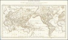
Shows the Sea of Corea
Nice old color example of the Covens & Mortier edition of De L'Isle's map of the Eastern and Western Hemispheres, distinguishable from later states by the lack of any information regarding the Russian Discoveries after 1730.
Western Hemisphere
One of the earliest peninsular projections of California after Kino, in a configuration which became a standard for De L'Isle's and other maps.
The small piece of Cap Blanc and an inlet west of Quivira on the Northwest Coast of America foretells the mythical depictions of De Font and D'Aguilar, the Sea of the West and other myths . There is a hint of the mythical land bridge from Compagnie's Land to the Northwest Coast of America.
The voyages of Vaisseau in 1710, Mendana, Gaetan, Magellan, Le Maire, Halley and Tasman through the Pacific are all depicted, as is the West Coast of New Zealand.
No sign of the Antarctic, other than a note of a discovery by Drake just above the polar circle. The Pacific is dotted with mythical islands. Some detail along the east coast of Australia
Eastern Hemisphere
Terres Australes ou Antarctiques is named, but without any sign of land.
Tasman's route past Van Diemens Land is shown, with a classic incomplete Australia and only a tiny strait between New Guinea and Australia, referencing Dampier.
Edmund Halley route in the South Atlantic is noted, as is Route du St. Louis.
The return routes of Tasman and Le Maire are shown eat of New Guinea, as is Gaetan's route to Mindanao through the Pescadore Islands and Isles de Palaos.
The Sea of Korea (Mer de Coree is shown).
Johannes Covens (1697-1774) was a Dutch geographic publisher based in Amsterdam. He is best known for his collaboration with fellow publisher Cornelis Mortier (1699-1783). Pierre Mortier the Elder (1661-1711) had obtained a privilege in 1690 to distribute the works of French geographers in the Netherlands. After his widow continued the business for several years, Cornelis took over in 1719.
In 1721, Mortier forged a partnership with Covens, who had recently married Cornelis’ sister. They published under the joint name of Covens & Mortier. In 1774, upon the death of his father, Johannes Covens II (1722-1794) took over his father’s share. In 1778, the company changed its name to J. Covens & Zoon, or J. Covens & son.
Covens II’s son, Cornelis (1764-1825), later inherited the business and brought Petrus Mortier IV back into the fold. Petrus was the great-grandson of Petrus Mortier I. From 1794, the business was called Mortier, Covens & Zoon, or Mortier, Covens, & Son.
The business specialized in publishing French geographers including Deslisle, Jaillot, and Sanson. They also published atlases, for example a 1725 reissue of Frederik de Wit’s Atlas Major and an atlas, with additions, from the works of Guillaume Delisle. There were also Covens & Mortier pocket atlases and town atlases. The company profited from acquiring plates from other geographers as well. For example, the purchased Pieter van der Aa’s plates in 1730. Finally, they also compiled a few maps in house. At their height, they had the largest collection of geographic prints ever assembled in Amsterdam.
Pierre, or Pieter, Mortier (1661-1711) was a Dutch engraver, son of a French refugee. He was born in Leiden. In 1690 he was granted a privilege to publish French maps in Dutch lands. In 1693 he released the first and accompanying volume of the Neptune Francois. The third followed in 1700. His son, Cornelis (1699-1783), would partner with Johannes Covens I, creating one of the most important map publishing companies of the eighteenth century.
![[English Edition!] Nova Totius Terrarum Orbis Geographica Ac Hydrographica Tabula Auct. Henr: Hondio. . . . 1630](https://storage.googleapis.com/raremaps/img/small/78002.jpg)
![[Hand Drawn Map of the World]](https://storage.googleapis.com/raremaps/img/small/86629.jpg)
![[World] Generale Ptholemei](https://storage.googleapis.com/raremaps/img/small/94338.jpg)