|
||

|

|
|

|
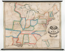
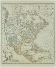
Texas on the Eve of Independence
Rare old color example of this detailed map of North America, showing Texas on the eve of Independence, 54-40 or Fight Oregon Territorial Border and Upper California as part of Mexico.
Austin, Houston and a number of other early details in Texas are shown.
Thomas Gamaliel Bradford (1802-1887) was an American geographic publisher. He hailed from Bradford, Massachusetts and began his publishing career by working for the America Encyclopedia. Then, he edited and republished the Atlas Designed to Illustrate the Abridgement of Universal Geography, Modern & Ancient, which had originally been offered in French by Adrian Balbi. In 1835, he published another atlas, A Comprehensive Atlas: Geographical, Historical & Commercial, and, in 1838, An Illustrated Atlas Geographical, Statistical and Historical of the United States and Adjacent Countries. His interests were primarily in educational publishing and he was one of the first mapmakers to show Texas as an independent country.