|
||

|

|
|

|
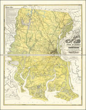
The most important and influential map of South Carolina during the British Colonial era. De Brahm was a German born military officer who befriended the Bishop of Augsburg, who was then promoting a Georgia Colony to displaced Germans. De Brahm emigrated to Georgia in 1751 and was soon employed as a surveyor in Georgia and South Carolina, where he was appointed surveyor general in 1754. De Brahm undertook an extensive coastal survey during the first part of the decade and in 1752 announced his intention to produce a map of the area, soliciting information from plantation owners who wished for their lands to appear on the map. De Brahm incorporated earlier surveys by William Bull, John Gascoigne and Hugh Bryan. He sent a draft to the Board of Trade, where it was quickly approved and Thomas Jefferys employed to engrave the map. The map is a vast improvement over earlier maps, accurately depicting the course of rivers and tributaries, correctly locating islands and parishes. An unsual topographical section is included at the northern border. The cartouche illustrates the colonies lucrative indigo trade. The map is known in two states, the present state and a second issued in 1780 with a different title. This example has been joined and laid on archival paper, with minor restorations along several of the old folds and in the margins, but is still an attractive and highly decorative example of the this now very rare map. The map has not appeared in a dealer catalogue in the past 25 years.
Thomas Jefferys (ca. 1719-1771) was a prolific map publisher, engraver, and cartographer based in London. His father was a cutler, but Jefferys was apprenticed to Emanuel Bowen, a prominent mapmaker and engraver. He was made free of the Merchant Taylors’ Company in 1744, although two earlier maps bearing his name have been identified.
Jefferys had several collaborators and partners throughout his career. His first atlas, The Small English Atlas, was published with Thomas Kitchin in 1748-9. Later, he worked with Robert Sayer on A General Topography of North America (1768); Sayer also published posthumous collections with Jefferys' contributions including The American Atlas, The North-American Pilot, and The West-India Atlas.
Jefferys was the Geographer to Frederick Prince of Wales and, from 1760, to King George III. Thanks especially to opportunities offered by the Seven Years' War, he is best known today for his maps of North America, and for his central place in the map trade—he not only sold maps commercially, but also imported the latest materials and had ties to several government bodies for whom he produced materials.
Upon his death in 1771, his workshop passed to his partner, William Faden, and his son, Thomas Jr. However, Jefferys had gone bankrupt in 1766 and some of his plates were bought by Robert Sayer (see above). Sayer, who had partnered in the past with Philip Overton (d. 1751), specialized in (re)publishing maps. In 1770, he partnered with John Bennett and many Jefferys maps were republished by the duo.