This item has been sold, but you can enter your email address to be notified if another example becomes available.


|
||

|

|
|

|
Stock# 59676
Description
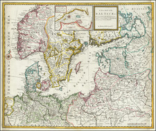
Rare Danish Sea Chart of The Kattegattet
Rare Danish Sea chart of the Eastern Danish Coastline and Southwestern Swedish Coastline, published in Copenhagen in 1773.
The chart extends from Rugen and Kiel in the south to Rerrikstad and Moss (Norway) in the north and east to Blekinge and Bornholm.
Christian Carl Lous (1724 - 1804) was a Danish mathematician, navigation director and poet.
Includes a third title in English:
New and Correct Mercators Chart (to be used also as a plain Chart) of the Baltick Sea from Faerder to Kiel and from Ekernförd to Carlscrona founded upon Trigonometrical Surveyings and Astronomical Observations.
Rarity
OCLC locates one surviving example: Herzogin Anna Amalia Bibliothek (Weimar)
Condition Description
Three sheets, joined as issued. Flattened, cleaned and restored.