|
||

|

|
|

|
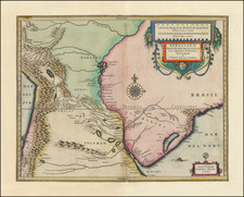
Striking Manuscript Map of Santa Catarina Island in Southern Brazil
Finely-wrought manuscript map showing the entirety of Ilha de Santa Catarina just off the coast of Brazil. The map seemingly dates from the period just after the island was transferred back to Portugal after the Spanish seized it.
The west-oriented map includes Santa Catarina and the mainland coast to Bombinhas. The land is blanketed in hachure marks to show the hilly terrain of the area. There are two scales in the lower right.
Letters serve as identifiers for key points of interest. A legend in the lower left explains that these are forts, part of a ring of defenses constructed in the mid-eighteenth century. It also identifies the village of Santa Catarina, also known as Desterro (A), a customs point for trade (H), and a peninsula notable for its whales (G).
The style of the map, particularly the north arrow and the hachures, suggest a date of creation in the later-eighteenth century, ca. 1780.
Ilha de Santa Catarina
The island came to prominence just before this map was drawn, but the Portuguese had already been on the island for three centuries by that time. Originally, the island was settled by Carijós Indians; archaeological evidence shows that they had been on the island 4,000 years ago.
The Portuguese arrived in roughly 1514 and called the island Ilha dos Patos. It was renamed in 1526 as Ilha de Santa Catarina. Originally, the main value of the island to the Portuguese was as a watering and supply station for ships en route to the Río de la Plata region to the south.
The first Portuguese settlement was officially founded in 1673, when a group of bandeirantes, or pioneers (literally flag bearers), established an agricultural colony. Five years later, they had a chapel consecrated to Nossa Senhora do Desterro, the name of their small town. Desterro was designated a village by the Portuguese town in 1714, and a town in 1726. On this map, Desterro is called Santa Catarina.
From the early eighteenth century onward, the Ilha de Santa Catarina increased in strategic value. It was located midway between Rio de Janeiro and Buenos Aires; the former was a Portuguese holding, the latter Spanish, but both were large and important ports. In 1739, the island was named a capitania, an administrative unit within the Portuguese empire. Desterro was named as the capital and construction began on the imposing fortresses included on this map.
Just before this map was drawn, the fortifications were tested. As tensions mounted over control of what is today Uruguay, the Spanish launched a naval attack on Santa Catarina. The fleet landed in the north of the island, easily bypassing the forts and the Portuguese ships. The island was not in Spanish hands for long, however, as it was returned to the Portuguese in the Treaty of San Ildefonso in 1777.
Also at mid-century, the population of the island boomed. 6,000 settlers arrived from the Azores and Madeira, kickstarting the agriculture, cotton, and linen industries. They also brought with them their customs and cuisine, both of which influenced the culture of the island immensely.
This map shows Santa Catarina just after the most important period in its history. It depicts the island as fortified, populated and Portuguese, as it only recently had escaped a Spanish occupation. Manuscripts from this period are not common and this map would make a fine addition to any collection of Brazilian maps.
![[San Salvador / Bahia] Carte Reduite De La Baie De Todos os Santos Et De Ses Atterages Situes a la Cote du Bresil Leve in 1819 dans la Campagne de la Corvette la Bayadere et du Brick le Favory par M.M. Givery et Gressier . . . . . . 1823](https://storage.googleapis.com/raremaps/img/small/62801.jpg)