|
||

|

|
|

|
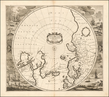
Fine map of the mythical island of Frislandia, based upon the writings of Nicolo Zeno, a 16th Century Venetian Noble, who reported that he had found family journals reflecting voyages to America in the 14th Century.
Frislandia was believed to lie east of Greenland and West of Iceland. The myth persisted into the 17tth Century and even the early 18th Century.
Coronelli's representation of the mythical island is perhaps the single largest format in which this mythical island appears, including topography, including 11 place names, apparently villages on the island.
The first modern description of the Zeno family travels in the new world appeared in a 1558 travel book describing a pre-Columbian voyage to the New World in 1380 by Ventians Nicolo and Antonio Zeno, accompanied by a map. Many historians regard the map and accompanying narrative as a hoax, perpetrated by the younger Zeno to make a retroactive claim for Venice as having discovered the New World before Christopher Columbus. The evidence against the authenticity of the map is based largely on the appearance of many non-existent islands in the North Atlantic and off the coast of Iceland. One of these non-existent islands was Frisland, where the Zeno brothers allegedly spent some time.
In addition to propagating the myth of the Zeno voyage, the Zeno map depicted many of the fictitious islands of the Atlantic in remarkable detail, including Frisland (with 32 places named), Deogeo, Estotiland, Estland, and the monastery of S. Tomas in Greenland. Many of Zeno's mythical islands were depicted on maps for centuries, mainly because Gerard Mercator accepted the account of Zeno's voyage as authentic and adopted much of it in his famous large 1569 world map and his 1595 map of the North Pole. Ortelius in turn used the map as a prototype for his map of the North Atlantic. Frobisher and Davis accepted the map for their explorations in the 1570's and 1580's, respectively.
The Zeno brothers, Nicolo (1326-1402) and Antonio, (d. 1403) were noted Italian navigators from Venice, who flourished in the second half of the 14th century. They were brothers of the Venetian naval hero Carlo Zeno. The Zeno family was an established part of the aristocracy of Venice and held the franchise for transportation between Venice and the Holy Land during the Crusades. The Zeno map of the North Atlantic first published in 1558 in Venice by Nicolo Zeno, a descendant of Nicolo Zeno, of the Zeno brothers. Nicolo Zeno published the map, along with a series of letters, claiming he had discovered them in a storeroom in his family's home in Venice.
The letters are divided into two parts. The first letters (from Nicolo to Antonio) tell how Nicolo set off in 1380 on a voyage from Venice to England and Flanders. Evidence exists that such a voyage took place, and that Nicolò returned to Venice around 1385. In the letters, Nicolò describes being stranded on an island between Great Britain and Iceland called Frislanda, which is described as being larger in size than Ireland. Nicolo is rescued by Zichmni, who is described as prince who owned some islands called Porlanda off the southern coast of Frislanda, and who ruled the duchy of Sorant, or Sorand, south-east of Frislanda.
Nicolo invites Antonio to come to Frislanda and the pair remain for fourteen years. Under Zichmni's direction, Antonio attacks "Estlanda", (perhaps the Shetland Islands), as indicated by the similarity of place names mentioned in the letters. Zichmni then attempts to attack Iceland. After finding it well defended, he attacks seven islands along its eastern side: Bres, Talas, Broas, Iscant, Trans, Mimant, Damberc. All of these islands are fictitious. Zichmni then builds a fort on Bres and leaves Nicolo in charge of it. Nicolo makes a voyage to Greenland and finds a monastery with central heating. He then returns to Frislanda, where he dies, having been in the north for four or five years.
After Nicolo's death, Zichmni receives word that a group of lost fisherman from Frislanda have returned after an absence of over 25 years. The fisherman describe having made landfall in the far west in unknown countries called Estotiland and Drogeo. The fishermen describe having encountered strange animals as well as cannibals, from whom they escaped only after teaching the cannibals how to fish. Inspired by the tales of the fishermen, Zichmni undertakes a voyage to the west with Antonio in charge of his fleet. To the west of Frislanda, they encounter a large (mythical) island called Icaria.
According to the letters, the inhabitants of Icaria greet them before they can make landfall. Only one person among the Icarians is able to speak a language that Zichmni understands. The inhabitants state that visitors to the island are not welcome and that they will defend the island to the last man if need be. Zichmni sails along the island looking for a place to make landfall, but the inhabitants chase him and Zichmni abandons the effort. Sailing west, they make landfall at a promontory called Trin on the southern tip of "Engrouelanda". Zichmni likes the climate and the soil, but his crew find it inhospitable. The sailors return home with Antonio, while Zichmni stays on to explore the area and build a town.
Vincenzo Maria Coronelli (1650-1718) was one of the most influential Italian mapmakers and was known especially for his globes and atlases. The son of a tailor, Vincenzo was apprenticed to a xylographer (a wood block engraver) at a young age. At fifteen he became a novice in a Franciscan monastery. At sixteen he published his first book, the first of 140 publications he would write in his lifetime. The order recognized his intellectual ability and saw him educated in Venice and Rome. He earned a doctorate in theology, but also studied astronomy. By the late 1670s, he was working on geography and was commissioned to create a set of globes for the Duke of Parma. These globes were five feet in diameter. The Parma globes led to Coronelli being named theologian to the Duke and receiving a bigger commission, this one from Louis XIV of France. Coronelli moved to Paris for two years to construct the King’s huge globes, which are 12.5 feet in diameter and weigh 2 tons.
The globes for the French King led to a craze for Coronelli’s work and he traveled Europe making globes for the ultra-elite. By 1705, he had returned to Venice. There, he founded the first geographical society, the Accademia Cosmografica degli Argonauti and was named Cosmographer of the Republic of Venice. He died in 1718.
![[ Canary Islands and Madeira Islands ] Isola di Canarie. . [with] Isola Madeira](https://storage.googleapis.com/raremaps/img/small/98646.jpg)