|
||

|

|
|

|
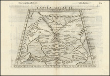
Stählin’s Controversial Map of the North Pacific—Alaska as an Island!
Rare early map depicting the Bering Strait and the newly discovered Aleutian Islands, shortly before the region was visited by Captain James Cook in 1778.
This map was published in the London Magazine in 1775, a year after the map first appeared in English. The work had first been translated to English at the urging of a Fellow of the Royal Society, so it’s publication in a magazine shows that the geographic debates surrounding the Pacific were of wider popular interest.
Jacob von Stählin first made the map for the Russian Academy of Sciences in 1773. It was then produced in a reduced form for the Society’s annual publication. Stählin produced a German edition in Stuttgart in 1774, with the map re-engraved by Jonathan Lenz. The German text and map caught the eye of Fellow of the Royal Society of London Michael Maty, who saw it translated to English, with the map engraved by Thomas Kitchin.
The map, which later proved controversial when tested by James Cook, depicts the parts of the North Pacific which Russian explorers probed in the seventeenth and eighteenth centuries. It illustrates several routes, including:
- Three Russian ships which arrived at Kamchatka in 1648, led by Semen Dezhnev. He led the group from the Kolyma River south of the Anadyr River. He described having sailed around a rocky promontory, which was most likely the Chukotskiy Peninsula. This was the first time Europeans has sailed around the eastern tip of Asia. However, Dezhnev’s reports remained unused and his achievement only vaguely understood until found by Gerhard Friedrich Müller of the Russian Academy of Sciences in archives in Yakutsk in the early-eighteenth century.
- The route of Captain Vitas Bering on his two North Pacific expeditions (1725-30, 1733-43). Bering was a Danish sailor who served in the Russian Navy. The First Kamchatka Expedition, which began in 1725, aimed to explore the extent of Siberia and to determine a route to America. The voyage was long and difficult; the crew traveled nineteen months overland from St. Petersburg before even reaching the Pacific coast at Okhotsk. From there, they sailed northeast along the coast of Kamchatka until they reached what would later be known as the Bering Strait.
Bering and his crew sailed around East Cape (today known as Cape Dezhnev) and saw that the coast turned back west toward Russia. He concluded that Asia and America were not connected and, although the expedition would spend another winter at Kamchatka, Bering was unable to locate any land to the east of the East Cape. The crew returned to St. Petersburg in 1730, after five years away.
After criticism for not making contact with America, Bering proposed the Second Kamchatka Expedition. However, during the voyage his ships were separated, weather was poor, and the crew became exhausted and sick. Bering himself became ill and eventually died on what is now known as Bering Island, near the coast of Kamchatka. Despite the deaths of nearly half of the crew, the expedition did eventually return to St. Petersburg with scientific and geographic information. They had traced the panhandle of Alaska, the Aleutian archipelago, opening the North Pacific to further Russian exploration.
- The route of Lieutenant Ivan Synd (here Sindo) in 1764, 1765, 1766, 1767, and 1768. Synd, who has sailed on the Second Kamchatka Expedition, was in search of the Northwest Passage, but he also hoped to clarify to what extent western Alaska was a peninsula or an archipelago.
The depiction of the Bering Strait and the Aleutians differs greatly from Müller’s map of 1758, then the most-widely referenced map of the region. Rather than the vague outline of the North American mainland trailing out into the Aleutians, Stählin shows a blunt North America with several large islands, the primary of which is named "I. Alaschka." All of these islands are closer to Asia than America.
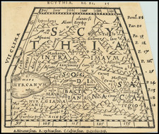
The Bering Strait, Stachtan Nitada, and the Northwest Passage
The first maps to include the findings of the Bering expeditions appeared in France in the early 1750s, followed by a German map by Gerhard Müller, academician and member of the second Kamchatka Expedition, first published in 1754 and distributed more widely in a 1758 edition. These maps, though they differed in many respects, show the strait between the continents and the westward thrust of the Alaskan mainland.
In the 1760s, Russian fur traders discovered more and more of the Aleutian Islands, some of which are shown here. In 1764, Lieutenant Ivan Synd led his own voyage to the Bering Sea in search of a navigable passage from the Pacific through the Arctic. He produced several maps, all but one of which have been lost. The map that does survive shows a series of islands nearly touching Kamchatka, not a peninsula.
As a result of Synd’s findings, Jacob von Stählin, secretary to the Russian Academy of Sciences, created a modified 1773 Russian edition of Müller’s chart which converted Müller’s large peninsula to a string of islands. This was then reduced for inclusion in the Academy’s calendar. It then appeared in a German edition and an English edition in 1774; the latter was entitled, “A Map of the New Northern Archipelago discover’d by the Russians.”
One of the most enduring, and controversial, details of the Stählin map is the toponym Stachtan Nitada on the North American mainland. This appears to the be the second use of the name; the first was a little-known 1767 map by midshipman Filip Vertyuglov which includes Stachtan Nitada where Cape Gvozdev would be, just as in the Stählin map.
Stachtan Nitada is supposedly a place at which Synd landed and is near the sighting of the Alaskan mainland by the Russians in 1730. Stählin’s book and map excited members of the Royal Society of London, who ensured that the German language publication was translated into English by the end of 1774.
However, Stachtan Nitada’s precise location and importance remained unclear to explorers, none more so than James Cook. Cook carried the English translation of Stählin’s map with him on this third voyage, which was focused on finding the Northwest Passage. What interested Cook was the strait between Stachtan Nitada and the nearest island to the west. It seemed to Cook and others planning his third voyage that this could be an entrance to a Northwest Passage.
When Cook arrived in search of the islands and passage in 1778, he found no such place. As J.C. Beaglehole, Cook’s twentieth-century editor, explains:
…no one could be too hard on Stählin. He had thrown the name Alaska on to an arbitrary island in the north; the other name Stachtan Nitada was unknown to either Russian or Aleut…As a cartographer he was naïve, even infantile; and he was unwise enough to speak slightingly of seamen. (Journals of Captain Cook, cxxxvii-cxxxviii)
Cook himself had choice words about Stählin and Stachtan Nitada. In his journal of October 1778, he wrote:
Stachtan Nitada as it is calld in the Modern maps, is a name quite unknown to these people, Indians as well as Russians, but both know it by the name of America. (251)
Of Stählin’s map, Cook wrote later in October 1778:
If Mr Stehlin was not greatly imposed upon what could induce him to publish so erroneous a Map? in which many of these islands are jumbled in in [sic] regular confusion, without the least regard to truth and yet he is pleased to call it a very accurate little Map? A Map that the most illiterate Seafaring men would have been ashamed to put his name to. (456)
The map reveals the conjectural, and contentious, nature of mapmaking in the late-eighteenth century, especially when those maps depicted a still unknown—but possibly lucrative—area like Alaska.
![[Bering Land Bridge, Alaska] Teller-Kougarok Area Compliments of Lomen Commercial Company Nome, Alaska](https://storage.googleapis.com/raremaps/img/small/45000jc.jpg)
![[Soviet Russian Ecology Propaganda Poster] Основы Водного Законодательства Союза ССР](https://storage.googleapis.com/raremaps/img/small/68343.jpg)