|
||

|

|
|

|
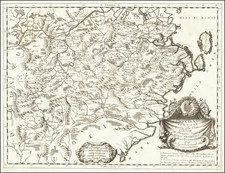
Fine Sixteenth-Century Map of Tartary and the Strait of Anian
Striking example of Magini's map of the Tartar Empire, from an early edition of Magini's Geographiae Universae tum Veteris tum Novae Absolutissimum.
The map features northeastern Asia and northwestern North America, with Japan sandwiched between them. The map offers a detailed, if still largely fanciful, treatment of the west coast of North America, stretching from what is today Alaska to the tip of Baja California. They are separated by the Strait of Anian. Ania itself is included as a province on mainland China.
The Tartar Empire extends from Europe to Asia, with the Caspian Sea evident. A bearded Tartar sits in a tent in the far north, while tall mountains are included in several places, and there is a lone yurt next to a hill.
There are several annotations included across the map. In the far north, near Argon, Christians are said to dwell. Other notes cite ancient and Medieval thinkers whose ideas influenced the geography of this map.
The map is supposed to show the extent and location of the Tartar Empire (also Tatar). Europeans referred to practically anyone from Central Asia as Tartars. An early confederation of Tartars was incorporated into the Mongol Empire under Genghis Khan. These largely nomadic groups interested Europeans for their supposed ruggedness, but in reality Magini and his contemporaries knew little accurate information about the Tartars.
This strait, believed to separate northwestern America from northeastern Asia, was related to the centuries-long quest to find a Northwest Passage connecting the Atlantic Ocean to the Pacific. The rumor of this strait and a Northwest Passage in general inspired many voyages of discovery, including those of John Cabot, Sir Francis Drake, Gaspar Corte-Real, Jacques Cartier, and Sir Humphrey Gilbert.
The term Anian itself comes from Marco Polo’s thirteenth-century accounts of his travels. Polo used the term to refer to the Gulf of Tonkin, but cartographers thought it could refer to this supposed strait between Asia and North America. The Strait of Anian, so named, first appeared in a 1562 map by Giacomo Gastaldi, and was later adopted by Bolognini Zaltieri and Gerard Mercator.
Giovanni Antonio Magini was an accomplished Italian cartographer, astronomer, astrologer, and mathematician—in short, a Renaissance man. Born in Padua, he studied philosophy in Bologna. His first publication was Ephemerides coelestium motuum, an astronomical treatise published in 1582. In 1588 he was selected, over Galileo Galilei, to fill the chair of mathematics at the University of Bologna. He died in that city in 1617.
Magini operated under a geocentric understanding of the universe and created his own planetary theory consisting of eleven rotating spheres. He published this theory in Novæ cœlestium orbium theoricæ congruentes cum observationibus N. Copernici (Venice, 1589). In the 1590s he published works on surveying and trigonometry, as well as invented a calculator. In 1596, he published a commentary of Ptolemy’s Geographia, which was published in several editions and languages. He labored for years on an atlas of Italy, which was printed posthumously in 1620. To pay for this project, Magini served as the math tutor to the son of the Duke of Mantua, as well as being the court astrologer to the Duke.
![(Second World War - Okinawa) [Large Battlefield Composite Map of Okinawa]](https://storage.googleapis.com/raremaps/img/small/63896.jpg)
![[ Southern California to Grand Canyon / Boulder Dam ] Inexpensive Sky Tours via Western Air Express](https://storage.googleapis.com/raremaps/img/small/76820.jpg)