


|
||

|

|
|

|
Massive Gold Region Illustrated In Gold
Rare late variant edition of this fantastic wall map of the United States, one of the most decorative coast to coast maps of the United States published prior to 1840.
As noted by Rumsey in describing the 1835 edition, the map is a marvelous almalgam of cartographic sources, but is perhaps most noteworthy for its striking image of the United States. Rumsey notes:
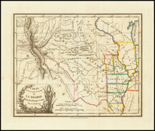
An unusual map in two sheets, showing the continent coast to coast. Tanner's influence from his North America map is evident in the west, and Long's map has influenced the plains, but Tanner's U.S. map is the primary source, in the Oregon District, the Plains, and the area east of the Mississippi. The Great Basin is filled with a table of distances and heights of mountains (which convention appears in several maps published in Hartford about this time by Thrall, Huntington, Olney's Geography, etc.). Wheat mentions the 1849 and 1850 editions of this map published by Reed and Barber, but this much earlier and different edition was unknown to him. Not in Phillips. Views of the Capital and the White House. Phelps did a related and somewhat smaller map in 1833 - see our copy. After the 1835 edition, no editions until the 1848 by Reed and Barber (see our 1849, 1850 and 1854 editions).
An unusual and are wall map showing the United States just after the Discovery of Gold in California in 1848 and the Compromise of 1850.
In 1845, Texas joined the United States as a new state. Following the Mexican War, the 1846 Treaty of Guadalupe Hidalgo transferred dominion over the northern Mexican states of New Mexico and Upper California to the United States.
This map shows the situation after the 1846 btreaty. Texas is shown in its very large, pre-1850 size, though with a configuration that is quite unusual. New Mexico is in its first Territorial configuration, including all of Arizona.
Upper California is now shown as California and Utah Territory. The recent discovery of gold is highlighted with a huge section of the map in gold and that is marked on this map with “Gold Region”. Also of interest in the territory is the “Mormon Ft.” at the south end of the Great Salt Lake. To the east of the continental divide is a very large Nebraska Territory-one of the earliest mentions of this proposed territory which wasn’t in fact created for another five years-and the Indian Territory. In this region are labels for the various Indian Tribes and a large shaded region labeled “Great American Desert.”
Detail in the east is very good, with towns, rivers, counties shown and each state and territory colored in a contrasting shade. A vignette of the U.S. Capitol graces the title cartouche and in the Gulf of Mexico is a drawing of the White House. A good early wall map showing this snap-shot of the country on the eve of one of the most important political developments of the century.
Rarity
The map is very rare.on the market, this being the first example we have seen in nearly 20 years. The last catalogued example of the map was the 1852 edition, offered by Richard Arkway Inc. in catalog 52, item #18.
![[ Northern Pacific Railroad ] NEW 7-30 GOLD LOAN OF THE Northern Pacific Railroad Co. SECURED BY FIRST MORTGAGE ON RAILROAD AND LAND GRANT. SAFE! PROFITABLE! PERMANENT!](https://storage.googleapis.com/raremaps/img/small/101828.jpg)

![(Lasalle's Final Expedition) Dernieres Decouvertes dans L'Amerique Septentrionale de M. De La Sale [i.e., La Salle], Mises au jour par M. le Chevalier Tonti, Gouverneur du Fort Saint Louis, aux Islinois.](https://storage.googleapis.com/raremaps/img/small/69476.jpg)
