|
||

|

|
|

|
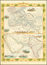
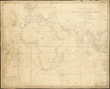
Fine large format map of Afghanistan, Iran, Turkmenistan, Tajikistan, Pakistan and northwestern India, with large inset maps of the Khyber Pass and Approaches to Kabul.
The map illustrates the theater of the Second Afghan War.
Includes a 12 page description of Afghanistan and 2 pages on the Kyhber Pass. The cover title is:
W.H. Smith & Son's Map of Afghanistan Showing The Indian & Russian Frontiers and Adjoining Countries. Also Enlarged Maps of Approaches to Kabul and of Khyber Pass, with Full Description of the Country
The Second Afghan War was fought between the British Raj and the Emirate of Afghanistan, during the rule of Sher Ali Khan.
After two years of war (1878-1880), the British forces prevailed, resulting in the Treaty of Gandamak. The Afghans were permitted to self rule, governed by local customs, but ceded control of foreign affairs to the British, along with giving up certain border territories to the British empire
Rarity
OCLC locates a single example (Yale).