|
||

|

|
|

|
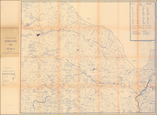
Manuscript Map of the Newly Created Administrative Territory of Karikal and its 3 Communes
Fine hand drawn map of the Territory of Karikal, showing the territory as newly divided into divided into communes under the Decree of March 12, 1880.
The three communes named and shown are Karaikal, Nedouneadou ( Nedungadu) and La Grande-aldee (Tirumalairayan).
The map shows towns, principal and secondary roads, bridges, rivers, and other details.
The area around Karaikal first became a French Colony by Treaty dated January 12, 1750, when Pratap Singh ceded to the France 81 villages around Karaikal and cancelled the annual rent of 2,000 pagodas payable for the villages. The territory passed several times between French and British control over the next six decades, before it was finally handed over to the French under the Treaty of Paris, 1814.
The map likely relates to the creation of 10 communes under the Decree of March 12, 1880, which created the three communes under "Karikal" (Karikal, the Grandee-Aldee and Nedouncadous".
Karikal was a French settlement and town on the Coromandel coast, lying between the taluks of Mayavaram, Nannilam, and Xegapatam in the Tanjore District of Madras and the Bay of Bengal. Karikal was divided into three communes, covering an area of 53 square miles, and governed by an Administrator subordinate to the Governor at Pondicherry. Each of the three communes — namely, Karikal, La Grande Aldee, and Xedungadu — had a mayor and council. The members were all elected by universal suffrage, but in the municipality of Karikal half the number of seats was reserved for Europeans or their descendants.
Many Indian laborers emigrated from Karikal to the French colonies. Inland customs were governed by a convention with the Madras Government. In 1899 Karikal was connected with Peralam on the Tanjore District Board Railway. The line is 45 miles long and owned by the French Government, but worked by the South Indian Railway.
Dating The Map
We have dated the map based upon the recent creation of the three communes and the existence of several manuscript maps of the Territory of Karikal in the Bibliotheque National de France.
![[Map of the Mount Everest Region] Mahalangur Himal Chomolongma -- Mount Everest](https://storage.googleapis.com/raremaps/img/small/95259.jpg)