|
||

|

|
|

|
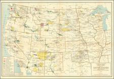
Very Rare St. Louis-Printed Map Showing that City's Nascent Transportation Connections to the Whole United States.
Lithographed folding map with some transport routes outlined in hand-color in red, printed and published by Julius Hutawa in St. Louis in 1854.
The map sometimes appears in the extremely rare pamphlet Annual Review. History of St. Louis, Commercial Statistics, Improvements of the Year, and Account of Leading Manufactories, &c. from the Missouri Republican, January 10, 1854.
The hand-coloring of the transportation routes effectively highlights the centrality of St. Louis.
The map shows five overland routes from the Mississippi to the West Coast.
It also shows the "Mormon City" to the southeast of the Great Salt Lake.
Not in Eberstadt, Decker, Soliday, Graff, Modelski, nor OCLC.
![[French America and the Triangular Trade] L'Amérique Françoise Où son Décrites La France Nouvelle, La France Insulaire, La France Equinoctiale, et autre pais Par P. Du Val d'Abbeville Geographe du Roy . . .](https://storage.googleapis.com/raremaps/img/small/91968.jpg)