


|
||

|

|
|

|
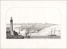
Engraved map of the entrance to the Santiago de Cuba Bay on the Southeast Coast of Cuba, from Bellin's Petit Atlas Maritime, prepared at the end of the Seven Years War.
Santiago de Cuba was the fifth village founded by Spanish conquistador Diego Velázquez de Cuéllar on July 25, 1515. Santiago was the starting point of the expeditions led by Juan de Grijalba and Hernán Cortés to the coasts of Mexico in 1518, and in 1538 by Hernando de Soto's expedition to Florida. The first cathedral was built in the city in 1528. From 1522 until 1589, Santiago was the capital of the Spanish colony of Cuba.
The city was plundered by French forces in 1553, by British forces in 1603 and again in 1662 under Christopher Myngs.
The city experienced an influx of French and British immigrants in the late 18th and early 19th centuries, many coming from Haiti after the Haitian slave revolt of 1791.
Jacques-Nicolas Bellin (1703-1772) was among the most important mapmakers of the eighteenth century. In 1721, at only the age of 18, he was appointed Hydrographer to the French Navy. In August 1741, he became the first Ingénieur de la Marine of the Dépôt des cartes et plans de la Marine (the French Hydrographic Office) and was named Official Hydrographer of the French King.
During his term as Official Hydrographer, the Dépôt was the one of the most active centers for the production of sea charts and maps in Europe. Their output included a folio-format sea atlas of France, the Neptune Francois. He also produced a number of sea atlases of the world, including the Atlas Maritime and the Hydrographie Francaise. These gained fame and distinction all over Europe and were republished throughout the eighteenth and even in the nineteenth century.
Bellin also produced smaller format maps such as the 1764 Petit Atlas Maritime, containing 580 finely-detailed charts. He also contributed a number of maps for the 15-volume Histoire Generale des Voyages of Antoine François Prévost.
Bellin set a very high standard of workmanship and accuracy, cementing France's leading role in European cartography and geography during this period. Many of his maps were copied by other mapmakers across the continent.
![[Havana / Approved by the Chart Committee of the Admiralty] Plan of the Harbour and city of the Havana, surveyed by Don Joseph de Rio, Captain in the Spanish Navy. 1798 . . . 1805](https://storage.googleapis.com/raremaps/img/small/89455.jpg)

![Plan of the City and Harbor of Havana [on sheet with:] Plan of Bahia de Matanzas](https://storage.googleapis.com/raremaps/img/small/89452.jpg)