|
||

|

|
|

|
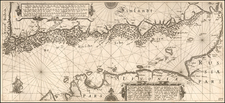
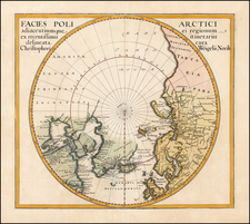
Willem Barentsz's Map of the Polar Regions, drawn from his observations during his third voyage of 1596-97 and engraved by Baptiste Van Deutecum.
The Barentsz map of the polar regions is a major landmark in Arctic cartography, depicting the details of his third voyage of 1596-7. After becoming stuck on the ice and being forced to winter in the Polar regions, Barentsz utilized his time to create an elaborate and highly decorative manuscript map depicting his observations.
The map shows a sophisticated understanding of the Polar coasts of Europe as far east as Novaya Zemlya (meaning "New World" in Russian, the furthest point of Barentsz's voyage). The mapping of the east coast of Novaya Zemlya is very comprehensive and features dozens of placenames. The coasts of Asia, further to the east are speculative, and beyond that lies the apocryphal Strait of Anian, supposedly the gateway from the Arctic to the Pacific Ocean.
In the west, Greenland and Iceland are well defined, although the mythical island of 'Frisland' (Friesland) is still placed in the northwest Atlantic. To the south and west of Greenland are the straits and the parts of Baffin Island recently discovered by Martin Frobisher and John Davis. Further north is the mythical "Estotiland", which originated from an apocryphal 14th Century Venetian voyage by the brothers Zeno.
Barentsz's map contains 34 illustrations of sea monsters, ships and whales, and an island named "Polus Magnetis." The first edition of the map is extremely rare. Among other important firsts, the map is the first to depict Spitsbergen, shown as "Het Nieuwe Land" above Finmarchia, discovered by Barentsz in 1596.
Historical Context: The Search for the Northeast Passage
During the early 1590s, the leading merchants of the Dutch Republic became very interested in opening trade routes with East Asia. Yet, they were deeply concerned that the established route to Asia, by way of the Cape of Good Hope and the Indian Ocean, was under the control of the Portuguese, who were enemies of the Dutch. Moreover, the established route was very long, and it was thought that any navigable polar route to Asia would be more expeditious. While exploring the Northwest Passage via the North American Arctic was considered, the failure of Martin Frobisher and John Davis's various attempts to find such a route in the 1570s and '80s discouraged any efforts in this direction. In 1553-54, the English adventurers Sir Hugh Willoughby and Richard Chancellor attempted to find a Northeast Passage to Asia, over Siberia, and while their mission ultimately failed in this regard, their progress and the nature of their reports convinced many in Amsterdam that such a passage could quite plausibly be opened, given another attempt. This torch was to be carried by Willem Barentsz.
Willem Barentsz (c. 1550-1597) was a Dutch map maker and explorer and one of the great pioneers of Arctic exploration. His first major work was an atlas of the Mediterranean, which he co-published with Petrus Plancius. Barentsz believed that the North Polar regions included a northeastern passage to the Pacific and that the polar regions consisted of open waters above Siberia, due to the fact that they would be exposed to the sun 24 hours per day. In the last decade of the 16th Century, Barentsz made 3 voyages to the North Polar regions. In June 1594, Barentsz led an expedition of 3 ships which sailed from Texel for the Kara Sea. On this voyage, the crew made the first ever encounter with a polar bear. Barentsz's first voyage reached the west coast of Novaya Zemlya. After coasting northward, the crew encountered large icebergs and were forced to turn back and return to Holland.
In 1595, Prince Maurice of Orange commissioned a second expedition led by Barentsz, which included 6 ships and a cargo of goods which were intended for trade with China. The expedition made several noteworthy encounters with Samoyed "wilde men" and polar bears, but was forced to turn back when they encountered a frozen Kara Sea.
In 1596, the Town Council of Amsterdam sponsored a voyage of two ships, in hopes of claiming a reward offered by the Dutch States-General, to the first expedition that navigated the northeast passage. Barentsz voyage discovered Spitsbergen, before reaching Bear Island on July 1, 1596 and Novaya Zembla on July 17, 1596. Shortly thereafter, Barentsz's ship was stranded by ice and the 16 man crew was forced to winter on the ice. After making it through the winter, the crew set out in two small boats on June 13, with Barentsz dying about 7 days later. Seven weeks later, the remainder of the crew reached Kola and were rescued by a Russian Merchant ship. The crew made it back to Amsterdam in November 1597, and several crew members wrote accounts of the voyage.
The wooden lodge where Barentsz's crew spent the winter was not revisited until 1871, when it was discovered by the Norwegian seal hunter Elling Carlsen. In 1875, Captain Gunderson returned to the site and collected several artifacts, including 2 maps and a handwritten translation of the Pet and Jackman voyages. In 1876, Charles L.W. Gardiner visited the site and collected many more artifacts and documents, including Barentsz's and Jacob van Heemskerck's notes on the settlement.
The map was originally published as a separately issued map, and several surviving copies can be found bound into composite atlases of the period. The map was also included in some copies of Linschoten's Navigatio ac itinerarium... (Amsterdam, 1598). Jan Huyghen van Linschoten (1563-1611) was perhaps the greatest world traveler of his age. His adventures from 1576 to 1592 in Iberia, Africa, and India, became the stuff of legend, and more than any other figure he was responsible for opening the young Dutch Republic to global trade and exploration. Following these voyages, Linschoten accompanied Barents on his first two voyages, and so had a vested personal (and commercial) interest in promoting his late friend's discoveries.
The map is a well-balanced masterpiece of Late Mannerist Style. This is testament to the fact that Linschoten commissioned Baptist van Deutecum, one of the finest engravers and artists in the Low Countries, to design and engrave the map.
While Barentz's attempts to find the Northeast Passage were ultimately not successful, his bravery and intellectual curiosity inspired future generations of polar explorers. His magnificent map was thus foundation on which all further oriental Arctic exploration was predicated, making it one of the most consequential maps of its era.
![Planisphere Physique ou l'on voit du Pole Septentrional ce que l'on connoit de Terres et de Mers Avec les Grandges Chaines de Montagnes . . . [Bay or Sea of the West]](https://storage.googleapis.com/raremaps/img/small/98378.jpg)