|
||

|

|
|

|
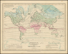
Scarce separately published map showing the World before, during and after the Great Flood described by the Old Testament.
Kircher offers a graphic depiction of his conjecture as to which parts of the world were flooded.
Among the more interesting features, the map shows Atlantis in the middle of the Atlantic Ocean.
Athanasius Kircher (1601-1680) was a Jesuit priest and a well-respected scholar known for his role in disseminating knowledge. Kircher was educated in Greek, Hebrew, and the humanities at Fulda, Paderborn, Cologne, Koblenz, and Mainz. After fleeing the Thirty Years’ War in Germany, Kircher worked as an academic at Avignon and, from 1634, Rome.
In Rome, Kircher served as an intellectual node, spreading information sent from around the world by Jesuit missionaries. Particular interests included ancient Egypt, astronomy, mathematics, medicine, music, and languages (both ancient and modern). He also made several maps and was a geographic compiler. It is likely he was the first person to depict the Pacific Ring of Fire on a map.
Kircher combined a mixture of hermeticism with nascent scientific inquiry, gaining him a reputation as one of the final Renaissance men. For example, he observed the eruptions of Etna and Stromboli. He had himself lowered into the crater of Vesuvius soon after an eruption to observe the changes wrought by the cataclysm. He experimented with bioluminescence by seeking the applications of firefly extract as a light source. He also made the first known Aeolian harp.
Kircher wrote 44 books, while over 2,000 of his manuscripts and letters survive. He also assembled one of the first natural history collections, the Museo Kircheriano or the Kircherianum, which was broken up after his death and became the foundation of several institutional collections.
![Hemisphere Septentrional du Globe Terrestre Veu en concave l'oeil estant au Pole AntArctique . . . 1696 [and] Hemisphere Superieur du Globe Terreste pour l'Horizon de Paris Veu en convexe l'oeil etant pose au zenith et a distance infinie du plan de projection . . . 1697](https://storage.googleapis.com/raremaps/img/small/85541.jpg)