|
||

|

|
|

|
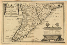
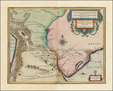
One of the Earliest Obtainable Maps of Chile
Nice example of Henricus Hondius' map of Chile, with 3 cartouches, sea monsters, sailing ships and 2 ornate compass roses.
Extends north to Mutantor and Puerto de Vetus and the R. de. Copayapo and locates at least 50 places, including Santiago de la Nueva Estremadura (Santiago), Baldivia, Osorno, Imperial, Ongol villa nueva de los Infantes, La Concepcion and L Serena.
The Andes are shown prominently, with an unnamed lake and Mendoza and San Juan de la Frontera as the only places named on the east side of the Lake.
Henricus Hondius (1597-1651) was a Dutch engraver and mapmaker, a member of a prominent cartographic family. His father, Jodocus Hondius, was also an engraver and geographer. While working with his father, Henricus was instrumental in the expansion and republishing of Mercator’s atlas, first published in 1595 and republished by Hondius in 1606.
Upon his father’s death in 1612, Henricus and his brother, Jodocus the Younger, took over the business. He set up his own shop in 1621, where he continued to release new editions of the Mercator atlas. Later, he partnered with his brother-in-law, Jan Janssonius, in continuing to expand and publish Mercator’s atlas, which would become known as the Mercator-Hondius-Janssonius atlas. Born and based in Amsterdam, he died there in 1651.