The item illustrated and described below is sold, but we
have another example in stock. To view the example which
is currently being offered for sale, click the
"View Details" button below.


|
||

|

|
|

|
Stock# 58632
Description
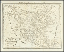
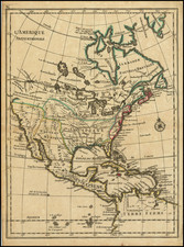
Scarce map of North America, with an early example of the Bay of the West from Le Rouge's Atlas nouveau portatif à l'usage des militaires et du voyageur, published in Paris in 1748.
The map shows both the Bay of the West and River connecting Hudson's Bay and the Pacific, as well as a second River of the West (Lahontan's River), which shows connecting Lake Superior to the Pacific, via the Lake of the Woods. The Great Lakes are misconfigured. Nice treatment on the interior of North America, with many Indian place names.
Condition Description
Minor soiling and foxing.
![Colton's North America [Wyoming attached to Dakota]](https://storage.googleapis.com/raremaps/img/small/98345.jpg)