|
||

|

|
|

|
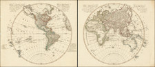
Striking World Map in Armenian, the Third Map Printed in Armenian and a Reduced Version of the First Map Printed in Armenian
Rare Armenian-language map of the world showing California as an island. It is a reduced version of the Vanandetsi world map of 1695, the first map printed in Armenian and a landmark in the history of cartography. The Vanandetsi map is practically unobtainable, making this map the earliest available Armenian world map.
The map is elegantly laid out, with a scalloped design in the border and the title unfurled in a banner across the top of the map. Within the hemispheres are sailing ships, sea monsters, and compass roses, in addition to the fascinating geography of ca. 1695, which is when the map upon which this reduced version is based was made. Dotted lines mark out national and imperial boundaries although, revealingly, the Ottoman Empire is not included. Rather, smaller polities including Hunasdan (Greece), Anadoli (Anatolia), and Hayasdan (Armenian) are labeled instead.
The map shows an intriguing and incomplete Australian coastline, with Van Diemen’s (Yergir Dimenian) land to the south. A jagged line denotes a possible southern continent and is called Andzanot Yergir Haravayin, “Unfamiliar Southern Land.” New Zealand is drawn with only its west coast shown and is labeled “opened 1642”, a reference to Abel Tasman’s voyage to the archipelago.
In Australia, or Nor Holandia (New Holland), two dates of “opening” are indicated: 1619 and 1644. The first refers to early Dutch expeditions to the western coast of Australia. 1619 is when Jacob d’Edel, in the Amsterdam, along with Frederik de Houtman in the Dordrecht sailed far south. The two ships came within sight of the western coast and called the stretch of Edel’s Land. 1644 seems to be a misunderstanding. Tasman’s second voyage took place in 1644 north of Australia. The southern coast of Australia shown here was first contacted in 1627 by Pieter Nuyts, a Dutch navigator who commanded the Gulden Zeepaert.
Yessov (also known as Yesso or Ezo, now called Hokkaido) is noted on the map, but at this time information about the extent of the northern island varied greatly. Here it indicates the southern tip of Kamchatka. On other maps it is shown as everything from a small island to a near-continent sized mass that stretches from Asia to Alaska.
Of particular interest on this map is the inclusion of New Sweden in what is today the Delaware Valley of northeast North America. New Sweden was a colony of the then-powerful Swedish empire from 1638 to 1655, when it was incorporated into the Dutch colony of New Netherland. However, the settlers retained relative autonomy and, when this map was made, the area had been taken by the English. Coronelli likewise included the colony on a map of 1688 and shows the enduring importance of the idea of the colony even after it had formally ceased to exist.
California as an Island
The most prominent geographical detail of the map is California's appearance as an island. From its first portrayal on a printed map by Diego Gutiérrez, in 1562, California was shown as part of North America by mapmakers, including Gerard Mercator and Abraham Ortelius. In the 1620s, however, it began to appear as an island in several sources.
This was most likely the result of a reading of the travel account of Sebastian Vizcaino, who had been sent north up the shore of California in 1602. A Carmelite friar who accompanied him later described the land as an island, a description first published in Juan Torquemada’s Monarquia Indiana (1613) with the island details curtailed somewhat. The friar, Fray Antonio de la Ascension, also wrote a Relacion breve of his geographic ideas around 1620. The ideas spread about New Spain and, eventually, most likely via Dutch mariners and perhaps thanks to stolen charts, to the rest of Europe.
By the 1620s, many mapmakers chose to depict the peninsula as an island. These included Henricus Hondius, who published the first atlas map to focus solely on North America with the island prominently featured in 1636. Hondius borrowed his outline of California from another widely-distributed map, that of Henry Briggs and printed in Samuel Purchas’ Hakluytus Posthumus or Purchas his Pilgrimes (1625).
Other prominent practitioners like John Speed and Nicolas Sanson also adopted the new island and the practice became commonplace. Father Eusebio Kino initially followed along with this theory but after extensive travels in what is now California, Arizona, and northern Mexico, he concluded that the island was actually a peninsula. Even after Kino published a map based on his travels refuting the claim (Paris, 1705), California as an island remained a fixture until the mid-eighteenth century.
Armenian cartographic printing and the first Armenian world maps
Printing in the Armenian language was an important project, particularly for those living in or traveling to Western Europe. The first Armenian printed works made in Amsterdam appeared in 1666-1670 and were overseen by Voskan Yerevantsi, a clergyman. He taught the trade of printing to his friend and fellow Armenian, Matheus Hovhanissean, who briefly set up his own Amsterdam printing house in the mid-1680s. Hovhanissean’s cousin, Bishop Nurijanean of Vanand, also known as Vanandetsi, had his nephews Lucas and Mikael Nurijaneans trained as printers in Italy.
Back in Armenia, the Bishop implored Matheus Hovhanissean to return to the Netherlands to set up another Armenian print shop. With Lucas and Mikael, Matheus did so; their printing press began production in 1694.
Bishop Vanandetsi wanted a world map in Armenian as a tool for merchants and as a symbol of the power and intelligence of Armenian scholars in a rapidly changing era. The Bishop hired Dutch brothers Hadrianus and Petrus Schoonebeek to prepare the copper plates for what would be a massive, eight-sheet world map with the latest in geographic knowledge and all Armenian toponyms. The double hemisphere world map, Hamataratz Ashkharhatsuyts, was the first printed map in the Armenian language ever produced.
After the Amsterdam printing house closed in 1717, the center of Armenian printed shifted to Venice, where the Armenian Mkhitarist Order was established on an island, San Lazzaro, in the Venice Lagoon. The order not only had a printing house, but also a museum, a library, and a reading room. For 265 years San Lazzaro would produce books and maps in Armenian and it became the largest Armenian publisher in the world. Indeed, in the eighteenth-century, it was the only Armenian printing house.
After 1717, the plates for the Hamataratz Ashkharhatsuyts fell out of use. In 1751, a priest of the Mkhitarist Order came across them for sale in Constantinople. He scrambled to gather the necessary funds, bought the plates, and took them to San Lazzaro. There, the plates were repaired and used to print a new run of the map intended to be sold to the Armenian communities of Russia and Venice. They continued to be sold until ca. 1782, even though the geographic information had not been updated.
Fifteen copies of the Amsterdam edition survive today, most in institutions. Of the Venice edition, only two examples are known. Both are practically unobtainable on the market.
The reduced version of the Hamataratz Ashkharhatsuyts, the third map printed in Armenian
After the Hamataratz Ashkharhatsuyts, no other Armenian map was produced until the Mkhitarists created a map of the Holy Land, dated 1746. Next to appear, in 1747, was this world map engraved by another Mkhitarist, Father Ingatius Khachaturean. Due to its smaller size, the map has fewer toponyms, but it is also updated slightly. For example, the Caspian Sea has a more accurate shape than on the Hamataratz Ashkharhatsuyts.
The map featured in the first volume of the Dictionary of the Armenian Language by founder of the order Abbot Mkhitar Sebastatsi, published in 1749. It was to be inserted at page 259, hence the number in the upper right corner. Later, it was also included in Father Stepannos Agonts’ Discourse of Geography published in 1817.
This map is rare and highly significant for the Armenian and the general history of cartography and the history of printing. It would make a significant addition to any collection of early printing, world maps, or Armenian maps.
Rouben Galichian, History of Armenian Cartography: Up to the Year 1918 (London and Yerevan: Bennett & Bloom and Zangak Publishing House, 2017); Raymond H. Kévorkian, “Armenian Publishing and the Quest for Modernity (16th–19th Centuries),” in Armenian Philology in the Modern Era: From Manuscript to Digital Age (Leiden: Brill, 2014); Celebrating the Legacy of Five Centuries of Armenian-Language Book Printing, 1512-2012, an exhibition booklet from the Armenian Research Center and the Alex and Marie Manoogian Museum, 2012; McLaughlin with Mayo, The Mapping of California as an Island: An Illustrated Checklist; Leighly California as an Island: An Illustrated Essay; Polk, The Island of California: A History of the Myth (Spokane: Arthur H. Clark Company, 1991).
![[Early Photographic Facsimile of the Lopo Homem Planisphere of 1554]](https://storage.googleapis.com/raremaps/img/small/67276.jpg)
![[ World Powers - Confrontation or Relaxation? ] Weltmachte-Konfrontation oder Entspannung?](https://storage.googleapis.com/raremaps/img/small/90939.jpg)
![[Early Photographic Facsimile of the Cantino Planisphere in 15 Sheets]](https://storage.googleapis.com/raremaps/img/small/67176.jpg)