|
||

|

|
|

|
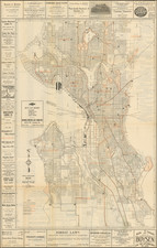
Unrecorded Early Map of Spokane, Washington
Fine large format map of Spokane Falls (now Spokane), Washington, published by Huber & Hough.
Built along the Spokane River, the map shows the many recent subdivisions, the names of larger property owners, County Fair Grounds, streets, roads, railroad lines, etc.
The lines of the Northern Pacific Railroad, Spokane Falls & Northern Railroad, Seattle Lake Shore & Eastern Railway and the Oregon Navigation & Railway Co line.
The map is the second earliest map of Spokane Falls which we were able to locate, pre-dated only by the W.H. Maxwell Map of Spokane Falls, W.T., published in 1883, recorded in only 2 examples (Yale and University of Wisconsin, Milwaukee). https://collections.lib.uwm.edu/digital/collection/agdm/id/8123
The present map is significantly larger than the Maxwell, reflecting the substantial growth of Spokane Falls between 1883 and 1889. The population of Spokane grew from about 350 people in 1880 to 19,992 by 1890.
Spokane
The City of Spokane was founded as "Spokan Falls" in 1873 by James Nettle Glover. The town name remained Spokan Falls until 1883, when the "E" was added to Spokan, which would remain the city name until 1891, when the word "Falls" was dropped.
Following the establishment of the modern boundaries of Spokane County in 1879, the town was incorporated in 1881 and became the county seat in 1887.
In 1889, the town was destroyed by fire, which destroyed 32 blocks of the central portion of the city.
The growth of Spokane can be tracked to the arrival of the Northern Pacific Railroad in 1881, with a link to the transcontinental railroad in 1883. The discovery of gold in the Coeur d'Alene mining district created a boom which established Spokane as the service center for the north Idaho mines. Spokane became the center of regional commerce and the main gateway to the Pacific Northwest.
The growth would continue uintil the national depression in 1893, followed by a another boom at the turn of the century.
Rarity
The map is apparently unrecorded. OCLC locates no examples of the map.
![[ California To Alaska -- Northwest Passage ] Quivirae Regnu cum alijs versus Borea](https://storage.googleapis.com/raremaps/img/small/60083.jpg)
![History of the Expedition under the Command of Captains Lewis and Clark, to the Sources of the Missouri Thence across the Rocky Mountains and Down the River Columbia to the Pacific Ocean, Performed During the Years 1804-5-6 [with map:] Map of Lewis and Clark's Track, Across the Western Portion of North America from the Mississippi to the Pacific Ocean](https://storage.googleapis.com/raremaps/img/small/92506.jpg)