|
||

|

|
|

|
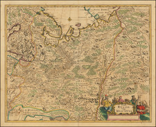
The General Map of the Kaluga Department from the Межевая экспедиция Mapping of Russia.
Detailed engraved cadastral map of the Kaluga region in western Russia.
The map is characteristic of the modern surveying that began in Russia under Catherine the Great. The present map is the general map of the region from a cadastral atlas of Kaluga. The Russian Academy of Sciences division for registering landlord ownership produced the Атлас Калужскаго наместничества in Saint Petersburg in 1782. The work was dedicated to Catherine the Great and was part of a wider effort, begun in the 1760s, to provide modern surveys of Russia. Another, less impressive, atlas of Kaluga was produced in 1785.
The 1782 atlas is quite rare; we find one example appearing at auction in Russia in 2017, making 800,000 Rubles (or around $12,000).
![Russian Empire [with] Chart of the Communication Between The Archipelago And Black Sea](https://storage.googleapis.com/raremaps/img/small/64013.jpg)
![[ St. Peterburg ] Plan de St. Petersbourg et de ses environs relatif au Memoire, concernant les moyens de mettre cette ville a l'agbri des inondations et d'etablir deux grands ports, dessine d'apres des cartes exactes, par le chevalier de Wiebeking, conseiller prive de S.M. le Roy de Baviere, etc. (With separately published Legende du Plan De St.-Petersbourg . . . )](https://storage.googleapis.com/raremaps/img/small/64539.jpg)
![[Plan of the City of Pskov with its suburban settlements] Планъ Города Пскова...](https://storage.googleapis.com/raremaps/img/small/67397.jpg)