


|
||

|

|
|

|
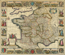
Rare separately published map of France, surrounded by views of French Cities, portraits and local costumes.
Rare carte-à-figures map in its 2nd state (of 4) with Cloppenburgh's imprint;.
This is the second state of the map of France first published "by Jodocus Hondius Jr. (before 1629)" (Sch./St. p. 351).
The geographical content is based mainly on Blaeu 1607.
Includes a fine decorative borders largely based upon on C. J. Visscher: portraits of Louis XIII. (as an adult with moustache; see preceding catalogue entry) and Anne of Austria, 4 armorial shields, 4 pairs of costumed figures at either side, and 12 views along top and bottom: Poitiers, Bourges, Paris, Lyon, Orleans, Angers, Calais, Rouen, Bordeaux, Marseille, Beaumont and Tours.
Johannes Cloppenburg (sometimes Cloppenburgh; also H. Jan Evertsz and Johannes Everhardus) was a Dutch cartographer. Based in Amsterdam, he was active between roughly 1610 and 1644. He worked closely with the Hondius/Jansson firm and is credited with the 1630 edition of the Atlas Minor.
![[Stop The Fake News!] Halte au Menteurs! Les Colo Bacilles Sement La Haine!](https://storage.googleapis.com/raremaps/img/small/59951.jpg)
![(France under Clovis) Franciae Status sub Regibus Primae Stirpis, ex Observationibus D. Mart. Bouquet Benedictini atque ex Dissertationibus D. Lebeuf Canonici Autis . . . [The State of France under its First Kings. . .]](https://storage.googleapis.com/raremaps/img/small/89714.jpg)
![[Piedmont Region, Italy and Berry Region, France] Biturigum provinciae quae Berrij : Vulgo dicitur chorographica descriptio / Pedemontanae totius Italiae fertilissimae Regionis unca cum suis finitimus elegantissimo descripto](https://storage.googleapis.com/raremaps/img/small/75339.jpg)
![[ France ] Galliae Regni Potentiss: Nova Descriptio Joanne Ioliveto Auctore . . .](https://storage.googleapis.com/raremaps/img/small/97834.jpg)