|
||

|

|
|

|
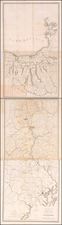
The First Map of Washington D.C. Published in Vienna!
Nice example of the first plan of Washington DC printed in Vienna, based upon Andrew Ellicott's manuscript plan.
This rare map of Washington, DC is based on the small Thackara & Vallance plan produced in March 1792 for The Universal Asylum And Columbian Magazine, which is considered the first printed plan of Washington. This example was published in Vienna in 1796, and includes a lettered key identifying key buildings and roads, such as the Capitol, the "President's Palace," and Connecticut Avenue.
The map itself shows a few major buildings including the Capitol and the Presidents House, while others are simply outlined. The proposed landscape design for the Mall is shown with considerably more detail.
The map was engraved by Christian Juncker and published in the Graetzer Zeitung, an Austrian weekly newspaper that was published in Graz from 1787 to 1866.
Mapping Washington DC
On January 24, 1791, President George Washington announced the permanent location of the national capital, a diamond-shaped ten-mile tract at the confluence of the Potomac and Eastern Branch Rivers. The original survey was performed by Andrew Ellicott and Benjamin Bannaker. Bannaker was the son of a free African-American woman and a former slave; he was a surveyor, naturalist, farmer, astronomer, and almanac author. In March of 1791, Major Pierre Charles L'Enfant was appointed by Washington to prepare a plan for the new city, with Andrew Ellicott serving as L'Enfant's assistant. L'Enfant turned out to be difficult to work with, and Thomas Jefferson and Washington ultimately suspended L'Enfant's participation in the project in 1792.
Andrew Ellicott took over the project using L'Enfants model as his base for completing the plan of the City. Philadelphia engravers James Thackera and John Vallance and Boston's Samuel Blodget Jr., were hired to produce engraved versions of Ellicott's manuscript plan. However, prior to the release of the large official plans, both engravers also engraved and printed a smaller version of the map.
Rarity
The map is very rare on the market. We note only an example sold by Jonathan Potter in 2008 (offered for about $2,600).
The map achieved wide circulation and within a few years, copies of the map had been made in England, Scotland, Germany and this very rare Viennese imprint.